Argyroúpoli geodata
Argyroúpoli (Attica) is a seat of a third-order administrative division; located in Greece in Europe/Athens (GMT+3) time zone. With population of 34,097 people, there are 53 cities with bigger population in this country. Compared to other cities in Greece, 77.8% of cities are located further ↑North; 71.4% of cities are located further ←West and 54.3% of cities have higher elevation than Argyroúpoli. Note1
Administrative division(s):
- Level 1: Attica
- Level 2: Nomarchía Athínas
- Level 3: Dimos Elliniko-Argyroupoli


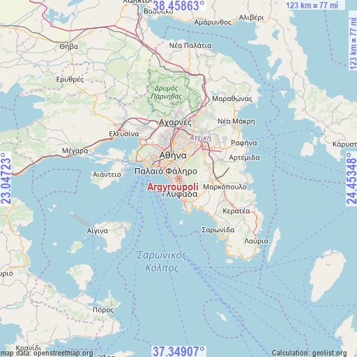
Argyroúpoli GPS coordinates[2]
37° 54' 21.384" North, 23° 45' 1.26" East
| Map corner | latitude | longitude |
|---|---|---|
| Upper-left | 38.45863°, | 23.04723° |
| Center: | 37.90594°, | 23.75035° |
| Lower-right: | 37.34907°, | 24.45348° |
| Map W x H: | 123.4×123.4 km | = 76.7×76.7mi |
| max Lat: | 41.72048° ⇑77.8% North |
| Argyroúpoli: | 37.90594° |
| min Lat: | ⇓22.2% South 34.8346° |
| min Long | Argyroúpoli | max Long |
| 19.40494° | 23.75035° | 29.59361° |
| W 71.4%⇐ | ⇒28.6% E |
Elevation
Elevation of Argyroúpoli is 67 m = 220 ft, and this is 101.9 m = 334 ft below average elevation for this country.
| Max E: |
1439 m = 4721 ft | 54.3% |
| Avg. | 168.9 m = 554 ft | |
| Argyroúpoli | 67 m = 220 ft | |
Min E: |
0 m = 0 ft | 45.7% |
See also: Greece elevation on elevation.city.
Geographical zone
Argyroúpoli is located in North temperate zone (between Tropic of Cancer and the Arctic Circle). Distance of this Northern Tropic circle is 1608.8 km =999.7 mi to South.| Distance of | km | miles | from Argyroúpoli |
|---|---|---|---|
| North Pole | 5792.3 | 3599.2 | to North |
| Arctic Circle | 3186.4 | 1979.9 | to North |
| Tropic Cancer | 1608.8 | 999.7 | to South |
| Equator | 4214.7 | 2618.9 | to South |


Nearby cities:
15 places around Argyroúpoli: (largest is in red/bold)
• Agios Dimitrios
3.4 km =2.1 mi,  333°
333°
• Dhafní
5.1 km =3.2 mi,  344°
344°
• Ellinikó
1.8 km =1.1 mi,  197°
197°
• Glyfáda
4.8 km =3 mi,  171°
171°
• Ilioúpoli
3.2 km =2 mi,  28°
28°
• Kaisarianí
6.5 km =4 mi,  11°
11°
• Kallithéa
6.6 km =4.1 mi,  317°
317°
• Moskháton
7.8 km =4.8 mi,  306°
306°
• Néa Smýrni
5.4 km =3.4 mi, 323°
• Palaió Fáliro
5 km =3.1 mi,  299°
299°
• Voúla
7.4 km =4.6 mi,  162°
162°
• Výronas
6.1 km =3.8 mi,  2°
2°
• Ymittos
5.3 km =3.3 mi,  358°
358°
• Zográfos
7.9 km =4.9 mi, 11°
• Álimos
2.4 km =1.5 mi,  281°
281°
Sources, notices
• [Note1] Compared only with cities in Greece existing in our database
• [Src1] Map data: © OpenStreetMap contributors (CC-BY-SA)
• [Src2] Other city data from geonames.org with taken over terms of usage.
• [Src3] Geographical zone / Annual Mean Temperature by Robert A. Rohde @ Wikipedia
