Eleónas geodata
Eleónas (Central Greece) is a populated place; located in Greece in Europe/Athens (GMT+3) time zone. With population of 655 people, there are 1490 cities with bigger population in this country. Compared to other cities in Greece, 64.6% of cities are located further ↑North; 63.3% of cities are located further ←West and 73.5% of cities have lower elevation than Eleónas. Note1


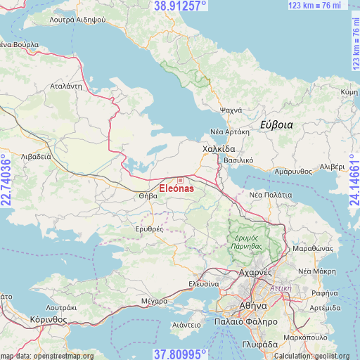
Eleónas GPS coordinates[2]
38° 21' 48.096" North, 23° 26' 36.528" East
| Map corner | latitude | longitude |
|---|---|---|
| Upper-left | 38.91257°, | 22.74036° |
| Center: | 38.36336°, | 23.44348° |
| Lower-right: | 37.80995°, | 24.14661° |
| Map W x H: | 122.6×122.6 km | = 76.2×76.2mi |
| max Lat: | 41.72048° ⇑64.6% North |
| Eleónas: | 38.36336° |
| min Lat: | ⇓35.4% South 34.8346° |
| min Long | Eleónas | max Long |
| 19.40494° | 23.44348° | 29.59361° |
| W 63.3%⇐ | ⇒36.7% E |
Elevation
Elevation of Eleónas is 193 m = 633 ft, and this is 24.1 m = 79 ft above average elevation for this country.
| Max E: |
1439 m = 4721 ft | 26.5% |
| Eleónas | 193 m 633 ft | |
| Avg. | 168.9 m = 554 ft | |
Min E: |
0 m = 0 ft | 73.5% |
See also: Greece elevation on elevation.city.
Geographical zone
Eleónas is located in North temperate zone (between Tropic of Cancer and the Arctic Circle). Distance of this Northern Tropic circle is 1659.7 km =1031.3 mi to South.| Distance of | km | miles | from Eleónas |
|---|---|---|---|
| North Pole | 5741.5 | 3567.6 | to North |
| Arctic Circle | 3135.6 | 1948.4 | to North |
| Tropic Cancer | 1659.7 | 1031.3 | to South |
| Equator | 4265.6 | 2650.5 | to South |


Nearby cities:
15 places around Eleónas: (largest is in red/bold)
• Asopía
8.8 km =5.5 mi,  144°
144°
• Dhrosiá
16.2 km =10.1 mi,  34°
34°
• Fáros
16.1 km =10 mi,  75°
75°
• Kallithea - Moustafádhes
5.8 km =3.6 mi,  183°
183°
• Kalochóri - Panteíchi
13.6 km =8.5 mi, 78°
• Ksyróvrisi
15.9 km =9.9 mi,  45°
45°
• Loukísia
12.9 km =8 mi,  1°
1°
• Mikrón Vathí
15.6 km =9.7 mi,  56°
56°
• Paralía Avlídhos
16.2 km =10.1 mi, 83°
• Paralía Vathéos
15.9 km =9.9 mi,  68°
68°
• Schimatári
12.3 km =7.6 mi,  96°
96°
• Thívai
11.7 km =7.3 mi,  248°
248°
• Vathí
14.7 km =9.1 mi, 71°
• Árma
3.9 km =2.4 mi,  110°
110°
• Áyios Thomás
15.9 km =9.9 mi,  127°
127°
Sources, notices
• [Note1] Compared only with cities in Greece existing in our database
• [Src1] Map data: © OpenStreetMap contributors (CC-BY-SA)
• [Src2] Other city data from geonames.org with taken over terms of usage.
• [Src3] Geographical zone / Annual Mean Temperature by Robert A. Rohde @ Wikipedia
