Áyios Thomás geodata
Áyios Thomás (Central Greece) is a populated place; located in Greece in Europe/Athens (GMT+3) time zone. With population of 1,292 people, there are 781 cities with bigger population in this country. Compared to other cities in Greece, 66.7% of cities are located further ↑North; 66.1% of cities are located further ←West and 77.5% of cities have lower elevation than Áyios Thomás. Note1


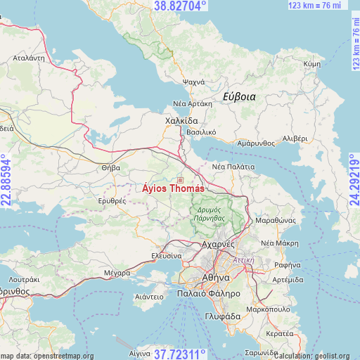
Áyios Thomás GPS coordinates[2]
38° 16' 37.812" North, 23° 35' 20.616" East
| Map corner | latitude | longitude |
|---|---|---|
| Upper-left | 38.82704°, | 22.88594° |
| Center: | 38.27717°, | 23.58906° |
| Lower-right: | 37.72311°, | 24.29219° |
| Map W x H: | 122.7×122.7 km | = 76.2×76.2mi |
| max Lat: | 41.72048° ⇑66.7% North |
| Áyios Thomás: | 38.27717° |
| min Lat: | ⇓33.3% South 34.8346° |
| min Long | Áyios Thomás | max Long |
| 19.40494° | 23.58906° | 29.59361° |
| W 66.1%⇐ | ⇒33.9% E |
Elevation
Elevation of Áyios Thomás is 242 m = 794 ft, and this is 73.1 m = 240 ft above average elevation for this country.
| Max E: |
1439 m = 4721 ft | 22.5% |
| Áyios Thomás | 242 m 794 ft | |
| Avg. | 168.9 m = 554 ft | |
Min E: |
0 m = 0 ft | 77.5% |
See also: Greece elevation on elevation.city.
Geographical zone
Áyios Thomás is located in North temperate zone (between Tropic of Cancer and the Arctic Circle). Distance of this Northern Tropic circle is 1650.1 km =1025.3 mi to South.| Distance of | km | miles | from Áyios Thomás |
|---|---|---|---|
| North Pole | 5751 | 3573.5 | to North |
| Arctic Circle | 3145.2 | 1954.3 | to North |
| Tropic Cancer | 1650.1 | 1025.3 | to South |
| Equator | 4256 | 2644.6 | to South |


Nearby cities:
15 places around Áyios Thomás: (largest is in red/bold)
• Asopía
8 km =5 mi,  287°
287°
• Avlónas
9.7 km =6 mi,  107°
107°
• Dílesi
9.8 km =6.1 mi,  46°
46°
• Fáros
13.9 km =8.6 mi,  12°
12°
• Kallithea - Moustafádhes
13.6 km =8.5 mi, 286°
• Kalochóri - Panteíchi
12.4 km =7.7 mi,  2°
2°
• Khalkoútsion
13.9 km =8.6 mi,  63°
63°
• Oinófyta
5.9 km =3.7 mi, 49°
• Paralía Avlídhos
11.9 km =7.4 mi,  16°
16°
• Pláka Dílesi
9.7 km =6 mi,  33°
33°
• Schimatári
8.1 km =5 mi,  356°
356°
• Skoúrta
7.7 km =4.8 mi,  205°
205°
• Sykámino
12.6 km =7.8 mi,  77°
77°
• Vathí
14.3 km =8.9 mi, 5°
• Árma
12.2 km =7.6 mi,  312°
312°
Sources, notices
• [Note1] Compared only with cities in Greece existing in our database
• [Src1] Map data: © OpenStreetMap contributors (CC-BY-SA)
• [Src2] Other city data from geonames.org with taken over terms of usage.
• [Src3] Geographical zone / Annual Mean Temperature by Robert A. Rohde @ Wikipedia
