Metókhion geodata
Metókhion (Peloponnese) is a populated place; located in Greece in Europe/Athens (GMT+3) time zone. With population of 761 people, there are 1316 cities with bigger population in this country. Compared to other cities in Greece, 84.7% of cities are located further ↑North; 53% of cities are located further ←West and 79.8% of cities have lower elevation than Metókhion. Note1


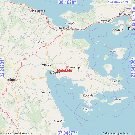
Metókhion GPS coordinates[2]
37° 36' 28.332" North, 22° 56' 45.348" East
| Map corner | latitude | longitude |
|---|---|---|
| Upper-left | 38.1628°, | 22.24281° |
| Center: | 37.60787°, | 22.94593° |
| Lower-right: | 37.04877°, | 23.64906° |
| Map W x H: | 123.9×123.9 km | = 77×77mi |
| max Lat: | 41.72048° ⇑84.7% North |
| Metókhion: | 37.60787° |
| min Lat: | ⇓15.3% South 34.8346° |
| min Long | Metókhion | max Long |
| 19.40494° | 22.94593° | 29.59361° |
| W 53%⇐ | ⇒47% E |
Elevation
Elevation of Metókhion is 275 m = 902 ft, and this is 106.1 m = 348 ft above average elevation for this country.
| Max E: |
1439 m = 4721 ft | 20.2% |
| Metókhion | 275 m 902 ft | |
| Avg. | 168.9 m = 554 ft | |
Min E: |
0 m = 0 ft | 79.8% |
See also: Greece elevation on elevation.city.
Geographical zone
Metókhion is located in North temperate zone (between Tropic of Cancer and the Arctic Circle). Distance of this Northern Tropic circle is 1575.7 km =979.1 mi to South.| Distance of | km | miles | from Metókhion |
|---|---|---|---|
| North Pole | 5825.5 | 3619.8 | to North |
| Arctic Circle | 3219.6 | 2000.6 | to North |
| Tropic Cancer | 1575.7 | 979.1 | to South |
| Equator | 4181.6 | 2598.3 | to South |


Nearby cities:
15 places around Metókhion: (largest is in red/bold)
• Arakhnaíon
8 km =5 mi,  7°
7°
• Argolikón
13 km =8.1 mi,  275°
275°
• Aria
10.5 km =6.5 mi,  248°
248°
• Asíni
10.1 km =6.3 mi,  225°
225°
• Ayía Triás
12.8 km =8 mi, 284°
• Drépanon
9 km =5.6 mi,  211°
211°
• Lefkákia
9.2 km =5.7 mi, 234°
• Ligourión
8.1 km =5 mi,  86°
86°
• Mánesis
12.1 km =7.5 mi,  298°
298°
• Náfplio
13 km =8.1 mi, 250°
• Néa Tírins
11.1 km =6.9 mi,  270°
270°
• Panarítis
11.1 km =6.9 mi, 283°
• Poullakídha
12.5 km =7.8 mi,  291°
291°
• Tolón
12.4 km =7.7 mi,  218°
218°
• Áyios Adhrianós
8.9 km =5.5 mi,  264°
264°
Sources, notices
• [Note1] Compared only with cities in Greece existing in our database
• [Src1] Map data: © OpenStreetMap contributors (CC-BY-SA)
• [Src2] Other city data from geonames.org with taken over terms of usage.
• [Src3] Geographical zone / Annual Mean Temperature by Robert A. Rohde @ Wikipedia
