Asprópyrgos geodata
Asprópyrgos (Attica) is a seat of a third-order administrative division; located in Greece in Europe/Athens (GMT+3) time zone. With population of 30,251 people, there are 60 cities with bigger population in this country. Compared to other cities in Greece, 71.2% of cities are located further ↑North; 66.2% of cities are located further ←West and 67.6% of cities have higher elevation than Asprópyrgos. Note1
Administrative division(s):
- Level 1: Attica
- Level 2: Nomarchía Dytikís Attikís
- Level 3: Dimos Aspropyrgos


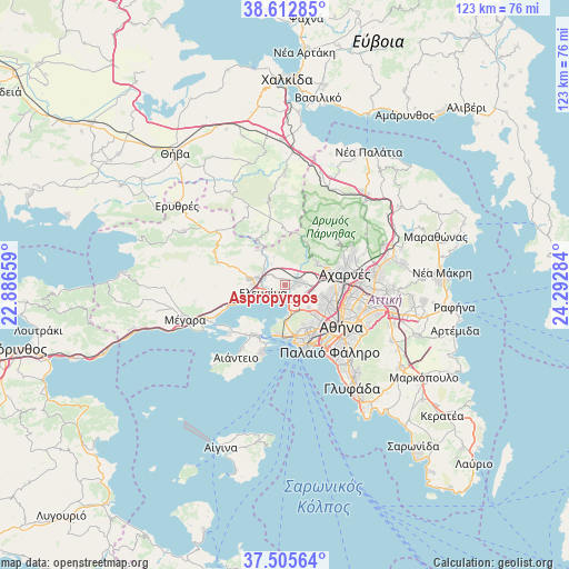
Asprópyrgos GPS coordinates[2]
38° 3' 40.824" North, 23° 35' 22.956" East
| Map corner | latitude | longitude |
|---|---|---|
| Upper-left | 38.61285°, | 22.88659° |
| Center: | 38.06134°, | 23.58971° |
| Lower-right: | 37.50564°, | 24.29284° |
| Map W x H: | 123.1×123.1 km | = 76.5×76.5mi |
| max Lat: | 41.72048° ⇑71.2% North |
| Asprópyrgos: | 38.06134° |
| min Lat: | ⇓28.8% South 34.8346° |
| min Long | Asprópyrgos | max Long |
| 19.40494° | 23.58971° | 29.59361° |
| W 66.2%⇐ | ⇒33.8% E |
Elevation
Elevation of Asprópyrgos is 35 m = 115 ft, and this is 133.9 m = 439 ft below average elevation for this country.
| Max E: |
1439 m = 4721 ft | 67.6% |
| Avg. | 168.9 m = 554 ft | |
| Asprópyrgos | 35 m = 115 ft | |
Min E: |
0 m = 0 ft | 32.4% |
See also: Greece elevation on elevation.city.
Geographical zone
Asprópyrgos is located in North temperate zone (between Tropic of Cancer and the Arctic Circle). Distance of this Northern Tropic circle is 1626.1 km =1010.4 mi to South.| Distance of | km | miles | from Asprópyrgos |
|---|---|---|---|
| North Pole | 5775 | 3588.4 | to North |
| Arctic Circle | 3169.1 | 1969.2 | to North |
| Tropic Cancer | 1626.1 | 1010.4 | to South |
| Equator | 4232 | 2629.6 | to South |


Nearby cities:
15 places around Asprópyrgos: (largest is in red/bold)
• Agía Varvára
10.1 km =6.3 mi,  142°
142°
• Chaïdári
8.7 km =5.4 mi,  129°
129°
• Elefsína
4.7 km =2.9 mi,  241°
241°
• Fylí
8.3 km =5.2 mi,  56°
56°
• Kamaterón
10.1 km =6.3 mi,  93°
93°
• Korydallós
9.9 km =6.2 mi,  149°
149°
• Magoúla
6.4 km =4 mi,  288°
288°
• Mándra
7.9 km =4.9 mi,  274°
274°
• Néa Zoí
9.6 km =6 mi,  284°
284°
• Peristéri
10.3 km =6.4 mi,  119°
119°
• Petroúpolis
8.6 km =5.3 mi,  104°
104°
• Pérama
10.5 km =6.5 mi,  188°
188°
• Skarmagkás
5.7 km =3.5 mi,  168°
168°
• Áno Liósia
10 km =6.2 mi,  75°
75°
• Ílion
10.1 km =6.3 mi,  107°
107°
Sources, notices
• [Note1] Compared only with cities in Greece existing in our database
• [Src1] Map data: © OpenStreetMap contributors (CC-BY-SA)
• [Src2] Other city data from geonames.org with taken over terms of usage.
• [Src3] Geographical zone / Annual Mean Temperature by Robert A. Rohde @ Wikipedia
