Anéza geodata
Anéza (Epirus) is a populated place; located in Greece in Europe/Athens (GMT+3) time zone. With population of 1,111 people, there are 908 cities with bigger population in this country. Compared to other cities in Greece, 53.1% of cities are located further ↑North; 90.9% of cities are located further →East and 97.4% of cities have higher elevation than Anéza. Note1


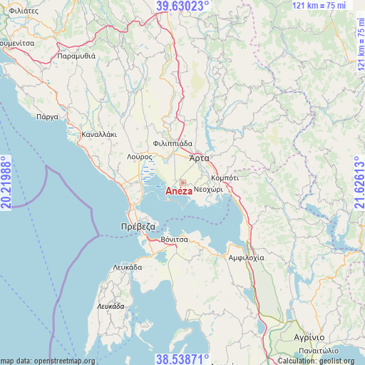
Anéza GPS coordinates[2]
39° 5' 11.688" North, 20° 55' 22.8" East
| Map corner | latitude | longitude |
|---|---|---|
| Upper-left | 39.63023°, | 20.21988° |
| Center: | 39.08658°, | 20.923° |
| Lower-right: | 38.53871°, | 21.62613° |
| Map W x H: | 121.4×121.4 km | = 75.4×75.4mi |
| max Lat: | 41.72048° ⇑53.1% North |
| Anéza: | 39.08658° |
| min Lat: | ⇓46.9% South 34.8346° |
| min Long | Anéza | max Long |
| 19.40494° | 20.923° | 29.59361° |
| W 9.1%⇐ | ⇒90.9% E |
Elevation
Elevation of Anéza is 4 m = 13 ft, and this is 164.9 m = 541 ft below average elevation for this country.
| Max E: |
1439 m = 4721 ft | 97.4% |
| Avg. | 168.9 m = 554 ft | |
| Anéza | 4 m = 13 ft | |
Min E: |
0 m = 0 ft | 2.6% |
See also: Greece elevation on elevation.city.
Geographical zone
Anéza is located in North temperate zone (between Tropic of Cancer and the Arctic Circle). Distance of this Northern Tropic circle is 1740.1 km =1081.2 mi to South.| Distance of | km | miles | from Anéza |
|---|---|---|---|
| North Pole | 5661 | 3517.6 | to North |
| Arctic Circle | 3055.2 | 1898.4 | to North |
| Tropic Cancer | 1740.1 | 1081.2 | to South |
| Equator | 4346 | 2700.5 | to South |


Nearby cities:
15 places around Anéza: (largest is in red/bold)
• Agía Paraskeví
6 km =3.7 mi,  76°
76°
• Akropotamiá
8.4 km =5.2 mi, 84°
• Chalkiádes
8.2 km =5.1 mi,  5°
5°
• Eleoúsa
8.1 km =5 mi,  24°
24°
• Kalamiá
8.8 km =5.5 mi, 5°
• Kalóvatos
4.5 km =2.8 mi,  354°
354°
• Komméno
10.4 km =6.5 mi,  115°
115°
• Kostakioí
6.3 km =3.9 mi,  28°
28°
• Neochóri
8.5 km =5.3 mi,  102°
102°
• Néa Kerasoúnta
9.7 km =6 mi,  324°
324°
• Pachykálamos
7.8 km =4.8 mi,  92°
92°
• Ráchi
3.7 km =2.3 mi,  326°
326°
• Rókka
9.1 km =5.7 mi, 11°
• Ágios Spyrídon
8.2 km =5.1 mi, 321°
• Árta
9.8 km =6.1 mi, 33°
Sources, notices
• [Note1] Compared only with cities in Greece existing in our database
• [Src1] Map data: © OpenStreetMap contributors (CC-BY-SA)
• [Src2] Other city data from geonames.org with taken over terms of usage.
• [Src3] Geographical zone / Annual Mean Temperature by Robert A. Rohde @ Wikipedia
