Platý geodata
Platý (Central Macedonia) is a populated place; located in Greece in Europe/Athens (GMT+3) time zone. With population of 2,228 people, there are 459 cities with bigger population in this country. Compared to other cities in Greece, 79.2% of cities are located further ↓South; 59.4% of cities are located further →East and 95.6% of cities have higher elevation than Platý. Note1
Administrative division(s):
- Level 1: Central Macedonia
- Level 2: Nomós Imathías
- Level 3: Dimos Alexandreia


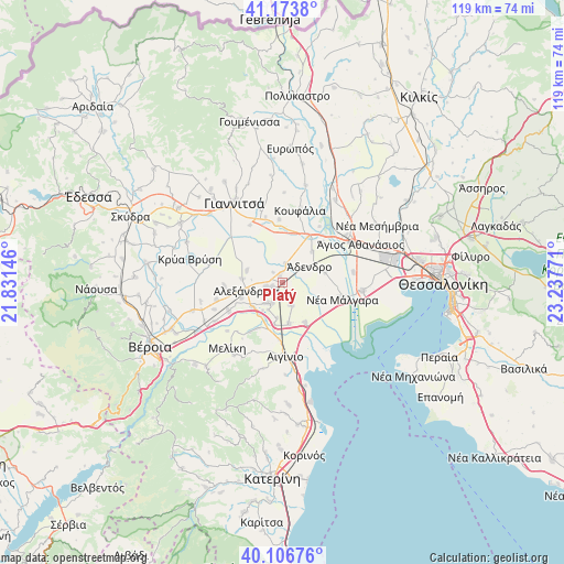
Platý GPS coordinates[2]
40° 38' 32.676" North, 22° 32' 4.488" East
| Map corner | latitude | longitude |
|---|---|---|
| Upper-left | 41.1738°, | 21.83146° |
| Center: | 40.64241°, | 22.53458° |
| Lower-right: | 40.10676°, | 23.23771° |
| Map W x H: | 118.6×118.6 km | = 73.7×73.7mi |
| max Lat: | 41.72048° ⇑20.8% North |
| Platý: | 40.64241° |
| min Lat: | ⇓79.2% South 34.8346° |
| min Long | Platý | max Long |
| 19.40494° | 22.53458° | 29.59361° |
| W 40.6%⇐ | ⇒59.4% E |
Elevation
Elevation of Platý is 5 m = 16 ft, and this is 163.9 m = 538 ft below average elevation for this country.
| Max E: |
1439 m = 4721 ft | 95.6% |
| Avg. | 168.9 m = 554 ft | |
| Platý | 5 m = 16 ft | |
Min E: |
0 m = 0 ft | 4.4% |
See also: Greece elevation on elevation.city.
Geographical zone
Platý is located in North temperate zone (between Tropic of Cancer and the Arctic Circle). Distance of this Northern Tropic circle is 1913.1 km =1188.7 mi to South.| Distance of | km | miles | from Platý |
|---|---|---|---|
| North Pole | 5488 | 3410.1 | to North |
| Arctic Circle | 2882.2 | 1790.9 | to North |
| Tropic Cancer | 1913.1 | 1188.7 | to South |
| Equator | 4519 | 2808 | to South |


Nearby cities:
15 places around Platý: (largest is in red/bold)
• Agkathiá
11.1 km =6.9 mi,  209°
209°
• Alexándreia
7.8 km =4.8 mi,  257°
257°
• Kleidí
9.7 km =6 mi,  150°
150°
• Koryfí
5 km =3.1 mi, 208°
• Kypséli
10.2 km =6.3 mi,  199°
199°
• Lianovérgi
2.4 km =1.5 mi,  250°
250°
• Loudías
4.1 km =2.5 mi,  9°
9°
• Mikró Monastíri
6.9 km =4.3 mi,  4°
4°
• Neochóri
7.9 km =4.9 mi,  288°
288°
• Niséli
8.2 km =5.1 mi,  229°
229°
• Parthéni
8.9 km =5.5 mi,  43°
43°
• Plátanos
8.7 km =5.4 mi,  171°
171°
• Tríkala
5.3 km =3.3 mi,  158°
158°
• Vrachiá
9.2 km =5.7 mi,  75°
75°
• Ádendro
6.7 km =4.2 mi,  61°
61°
Sources, notices
• [Note1] Compared only with cities in Greece existing in our database
• [Src1] Map data: © OpenStreetMap contributors (CC-BY-SA)
• [Src2] Other city data from geonames.org with taken over terms of usage.
• [Src3] Geographical zone / Annual Mean Temperature by Robert A. Rohde @ Wikipedia
