Alexándreia geodata
Alexándreia (Central Macedonia) is a seat of a third-order administrative division; located in Greece in Europe/Athens (GMT+3) time zone. With population of 13,665 people, there are 119 cities with bigger population in this country. Compared to other cities in Greece, 78.6% of cities are located further ↓South; 61.6% of cities are located further →East and 90.7% of cities have higher elevation than Alexándreia. Note1
Administrative division(s):
- Level 1: Central Macedonia
- Level 2: Nomós Imathías
- Level 3: Dimos Alexandreia


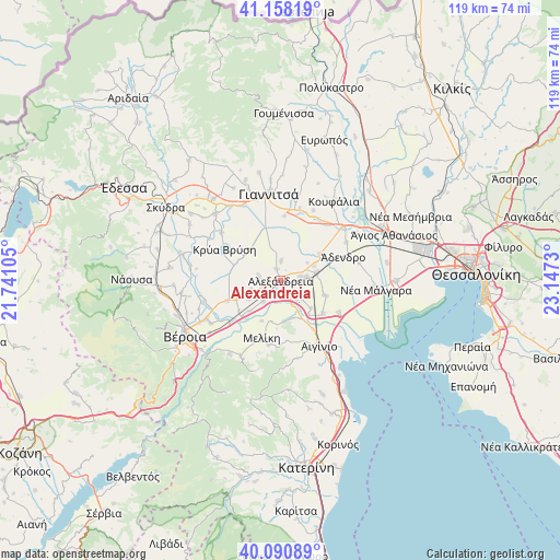
Alexándreia GPS coordinates[2]
40° 37' 36.012" North, 22° 26' 39.012" East
| Map corner | latitude | longitude |
|---|---|---|
| Upper-left | 41.15819°, | 21.74105° |
| Center: | 40.62667°, | 22.44417° |
| Lower-right: | 40.09089°, | 23.1473° |
| Map W x H: | 118.7×118.7 km | = 73.8×73.8mi |
| max Lat: | 41.72048° ⇑21.4% North |
| Alexándreia: | 40.62667° |
| min Lat: | ⇓78.6% South 34.8346° |
| min Long | Alexándreia | max Long |
| 19.40494° | 22.44417° | 29.59361° |
| W 38.4%⇐ | ⇒61.6% E |
Elevation
Elevation of Alexándreia is 8 m = 26 ft, and this is 160.9 m = 528 ft below average elevation for this country.
| Max E: |
1439 m = 4721 ft | 90.7% |
| Avg. | 168.9 m = 554 ft | |
| Alexándreia | 8 m = 26 ft | |
Min E: |
0 m = 0 ft | 9.3% |
See also: Greece elevation on elevation.city.
Geographical zone
Alexándreia is located in North temperate zone (between Tropic of Cancer and the Arctic Circle). Distance of this Northern Tropic circle is 1911.3 km =1187.6 mi to South.| Distance of | km | miles | from Alexándreia |
|---|---|---|---|
| North Pole | 5489.8 | 3411.2 | to North |
| Arctic Circle | 2883.9 | 1792 | to North |
| Tropic Cancer | 1911.3 | 1187.6 | to South |
| Equator | 4517.3 | 2806.9 | to South |


Nearby cities:
15 places around Alexándreia: (largest is in red/bold)
• Agkathiá
8.2 km =5.1 mi,  164°
164°
• Episkopí
7.8 km =4.8 mi,  239°
239°
• Kampochóri
6.6 km =4.1 mi,  253°
253°
• Kefalochóri
9.2 km =5.7 mi,  225°
225°
• Koryfí
5.9 km =3.7 mi,  116°
116°
• Kypséli
8.9 km =5.5 mi,  152°
152°
• Lianovérgi
5.5 km =3.4 mi,  79°
79°
• Loutrós
5.6 km =3.5 mi,  221°
221°
• Neochóri
4.3 km =2.7 mi,  1°
1°
• Niséli
3.8 km =2.4 mi, 159°
• Nisí
4.8 km =3 mi,  282°
282°
• Palaió Skyllítsi
10 km =6.2 mi,  256°
256°
• Platý
7.8 km =4.8 mi, 77°
• Pródromos
9.3 km =5.8 mi,  205°
205°
• Vrysáki
3.5 km =2.2 mi, 258°
Sources, notices
• [Note1] Compared only with cities in Greece existing in our database
• [Src1] Map data: © OpenStreetMap contributors (CC-BY-SA)
• [Src2] Other city data from geonames.org with taken over terms of usage.
• [Src3] Geographical zone / Annual Mean Temperature by Robert A. Rohde @ Wikipedia
