Pigés geodata
Pigés (East Macedonia and Thrace) is a populated place; located in Greece in Europe/Athens (GMT+3) time zone. With population of 770 people, there are 1305 cities with bigger population in this country. Compared to other cities in Greece, 88.6% of cities are located further ↓South; 84.7% of cities are located further ←West and 90.7% of cities have higher elevation than Pigés. Note1
Administrative division(s):
- Level 1: East Macedonia and Thrace
- Level 2: Nomós Kaválas
- Level 3: Dimos Nestos


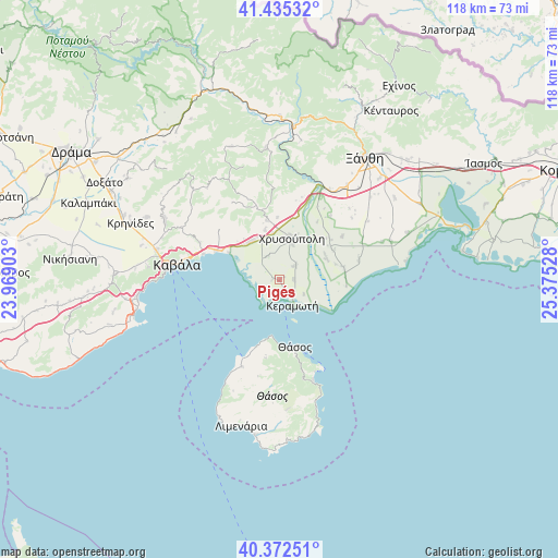
Pigés GPS coordinates[2]
40° 54' 21.78" North, 24° 40' 19.74" East
| Map corner | latitude | longitude |
|---|---|---|
| Upper-left | 41.43532°, | 23.96903° |
| Center: | 40.90605°, | 24.67215° |
| Lower-right: | 40.37251°, | 25.37528° |
| Map W x H: | 118.2×118.2 km | = 73.4×73.4mi |
| max Lat: | 41.72048° ⇑11.4% North |
| Pigés: | 40.90605° |
| min Lat: | ⇓88.6% South 34.8346° |
| min Long | Pigés | max Long |
| 19.40494° | 24.67215° | 29.59361° |
| W 84.7%⇐ | ⇒15.3% E |
Elevation
Elevation of Pigés is 8 m = 26 ft, and this is 160.9 m = 528 ft below average elevation for this country.
| Max E: |
1439 m = 4721 ft | 90.7% |
| Avg. | 168.9 m = 554 ft | |
| Pigés | 8 m = 26 ft | |
Min E: |
0 m = 0 ft | 9.3% |
See also: Greece elevation on elevation.city.
Geographical zone
Pigés is located in North temperate zone (between Tropic of Cancer and the Arctic Circle). Distance of this Northern Tropic circle is 1942.4 km =1207 mi to South.| Distance of | km | miles | from Pigés |
|---|---|---|---|
| North Pole | 5458.7 | 3391.9 | to North |
| Arctic Circle | 2852.8 | 1772.6 | to North |
| Tropic Cancer | 1942.4 | 1207 | to South |
| Equator | 4548.3 | 2826.2 | to South |


Nearby cities:
15 places around Pigés: (largest is in red/bold)
• Agíasma
1.3 km =0.8 mi,  279°
279°
• Chrysochóri
4.4 km =2.7 mi,  47°
47°
• Chrysoúpolis
9 km =5.6 mi,  11°
11°
• Erateinó
5.6 km =3.5 mi,  331°
331°
• Gravoúna
10 km =6.2 mi,  350°
350°
• Iliokentima
10.9 km =6.8 mi,  63°
63°
• Keramotí
6.3 km =3.9 mi,  152°
152°
• Néa Karváli
14.8 km =9.2 mi,  294°
294°
• Néa Karyá
3 km =1.9 mi,  89°
89°
• Petropigí
10.3 km =6.4 mi, 332°
• Pérni
10.9 km =6.8 mi,  343°
343°
• Thásos
14.6 km =9.1 mi,  167°
167°
• Zarkadiá
12.8 km =8 mi, 348°
• Ávato
12.8 km =8 mi, 60°
• Évlalo
13.8 km =8.6 mi, 51°
Sources, notices
• [Note1] Compared only with cities in Greece existing in our database
• [Src1] Map data: © OpenStreetMap contributors (CC-BY-SA)
• [Src2] Other city data from geonames.org with taken over terms of usage.
• [Src3] Geographical zone / Annual Mean Temperature by Robert A. Rohde @ Wikipedia
