Palaífyto geodata
Palaífyto (Central Macedonia) is a populated place; located in Greece in Europe/Athens (GMT+3) time zone. With population of 1,475 people, there are 678 cities with bigger population in this country. Compared to other cities in Greece, 84.6% of cities are located further ↓South; 65.7% of cities are located further →East and 81.5% of cities have higher elevation than Palaífyto. Note1


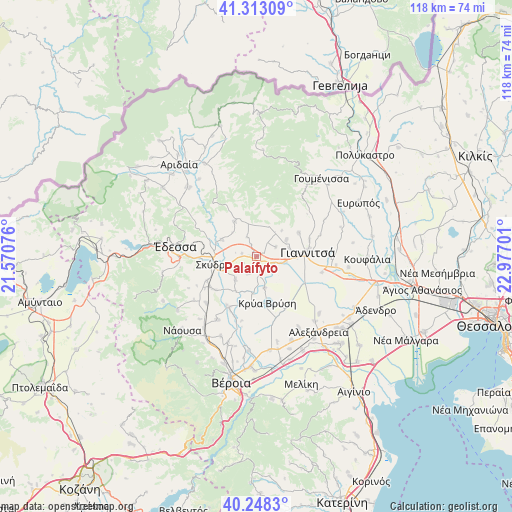
Palaífyto GPS coordinates[2]
40° 46' 58.188" North, 22° 16' 25.968" East
| Map corner | latitude | longitude |
|---|---|---|
| Upper-left | 41.31309°, | 21.57076° |
| Center: | 40.78283°, | 22.27388° |
| Lower-right: | 40.2483°, | 22.97701° |
| Map W x H: | 118.4×118.4 km | = 73.6×73.6mi |
| max Lat: | 41.72048° ⇑15.4% North |
| Palaífyto: | 40.78283° |
| min Lat: | ⇓84.6% South 34.8346° |
| min Long | Palaífyto | max Long |
| 19.40494° | 22.27388° | 29.59361° |
| W 34.3%⇐ | ⇒65.7% E |
Elevation
Elevation of Palaífyto is 16 m = 52 ft, and this is 152.9 m = 502 ft below average elevation for this country.
| Max E: |
1439 m = 4721 ft | 81.5% |
| Avg. | 168.9 m = 554 ft | |
| Palaífyto | 16 m = 52 ft | |
Min E: |
0 m = 0 ft | 18.5% |
See also: Greece elevation on elevation.city.
Geographical zone
Palaífyto is located in North temperate zone (between Tropic of Cancer and the Arctic Circle). Distance of this Northern Tropic circle is 1928.7 km =1198.4 mi to South.| Distance of | km | miles | from Palaífyto |
|---|---|---|---|
| North Pole | 5472.4 | 3400.4 | to North |
| Arctic Circle | 2866.5 | 1781.2 | to North |
| Tropic Cancer | 1928.7 | 1198.4 | to South |
| Equator | 4534.6 | 2817.7 | to South |


Nearby cities:
15 places around Palaífyto: (largest is in red/bold)
• Achladochóri
8.3 km =5.2 mi,  43°
43°
• Aravissós
7.1 km =4.4 mi,  19°
19°
• Axós
7.7 km =4.8 mi,  73°
73°
• Droseró
5 km =3.1 mi,  334°
334°
• Galatádes
3 km =1.9 mi,  169°
169°
• Kallípoli
3.5 km =2.2 mi,  283°
283°
• Kalývia
5.7 km =3.5 mi,  236°
236°
• Karyótissa
3.7 km =2.3 mi,  114°
114°
• Liparó
4.6 km =2.9 mi,  209°
209°
• Melíssi
6.7 km =4.2 mi,  98°
98°
• Néos Mylótopos
7.9 km =4.9 mi,  59°
59°
• Palaiós Mylótopos
4.9 km =3 mi, 62°
• Trifýlli
1.2 km =0.7 mi,  316°
316°
• Ágios Loukás
7.4 km =4.6 mi, 165°
• Áspro
7.2 km =4.5 mi,  223°
223°
Sources, notices
• [Note1] Compared only with cities in Greece existing in our database
• [Src1] Map data: © OpenStreetMap contributors (CC-BY-SA)
• [Src2] Other city data from geonames.org with taken over terms of usage.
• [Src3] Geographical zone / Annual Mean Temperature by Robert A. Rohde @ Wikipedia
