Liparó geodata
Liparó (Central Macedonia) is a populated place; located in Greece in Europe/Athens (GMT+3) time zone. With population of 550 people, there are 1698 cities with bigger population in this country. Compared to other cities in Greece, 83% of cities are located further ↓South; 66.3% of cities are located further →East and 81.5% of cities have higher elevation than Liparó. Note1


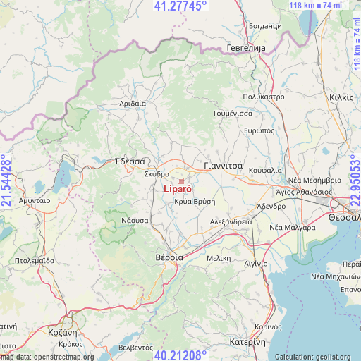
Liparó GPS coordinates[2]
40° 44' 48.84" North, 22° 14' 50.64" East
| Map corner | latitude | longitude |
|---|---|---|
| Upper-left | 41.27745°, | 21.54428° |
| Center: | 40.7469°, | 22.2474° |
| Lower-right: | 40.21208°, | 22.95053° |
| Map W x H: | 118.5×118.5 km | = 73.6×73.6mi |
| max Lat: | 41.72048° ⇑17% North |
| Liparó: | 40.7469° |
| min Lat: | ⇓83% South 34.8346° |
| min Long | Liparó | max Long |
| 19.40494° | 22.2474° | 29.59361° |
| W 33.7%⇐ | ⇒66.3% E |
Elevation
Elevation of Liparó is 16 m = 52 ft, and this is 152.9 m = 502 ft below average elevation for this country.
| Max E: |
1439 m = 4721 ft | 81.5% |
| Avg. | 168.9 m = 554 ft | |
| Liparó | 16 m = 52 ft | |
Min E: |
0 m = 0 ft | 18.5% |
See also: Greece elevation on elevation.city.
Geographical zone
Liparó is located in North temperate zone (between Tropic of Cancer and the Arctic Circle). Distance of this Northern Tropic circle is 1924.7 km =1196 mi to South.| Distance of | km | miles | from Liparó |
|---|---|---|---|
| North Pole | 5476.4 | 3402.9 | to North |
| Arctic Circle | 2870.5 | 1783.6 | to North |
| Tropic Cancer | 1924.7 | 1196 | to South |
| Equator | 4530.6 | 2815.2 | to South |


Nearby cities:
15 places around Liparó: (largest is in red/bold)
• Akrolímni
7.6 km =4.7 mi,  169°
169°
• Arsénio
8.3 km =5.2 mi,  243°
243°
• Esóvalta
4.6 km =2.9 mi,  162°
162°
• Galatádes
3 km =1.9 mi,  70°
70°
• Kallípoli
4.9 km =3 mi,  346°
346°
• Kalývia
2.7 km =1.7 mi,  289°
289°
• Karyótissa
6.1 km =3.8 mi, 65°
• Krýa Vrýsi
8.2 km =5.1 mi,  143°
143°
• Káto Lipochóri
5.8 km =3.6 mi,  281°
281°
• Palaífyto
4.6 km =2.9 mi,  29°
29°
• Skýdra
8.4 km =5.2 mi, 285°
• Stavrodrómi
4.7 km =2.9 mi,  213°
213°
• Trifýlli
5.1 km =3.2 mi,  15°
15°
• Ágios Loukás
5.2 km =3.2 mi,  128°
128°
• Áspro
3 km =1.9 mi,  245°
245°
Sources, notices
• [Note1] Compared only with cities in Greece existing in our database
• [Src1] Map data: © OpenStreetMap contributors (CC-BY-SA)
• [Src2] Other city data from geonames.org with taken over terms of usage.
• [Src3] Geographical zone / Annual Mean Temperature by Robert A. Rohde @ Wikipedia
