Nestório geodata
Nestório (West Macedonia) is a seat of a third-order administrative division; located in Greece in Europe/Athens (GMT+3) time zone. With population of 865 people, there are 1181 cities with bigger population in this country. Compared to other cities in Greece, 72.1% of cities are located further ↓South; 89.4% of cities are located further →East and 98.3% of cities have lower elevation than Nestório. Note1
Administrative division(s):
- Level 1: West Macedonia
- Level 2: Nomós Kastoriás
- Level 3: Dimos Nestorio


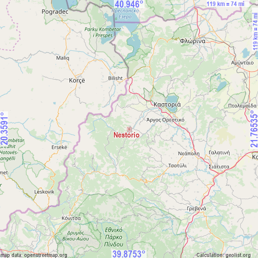
Nestório GPS coordinates[2]
40° 24' 46.008" North, 21° 3' 43.992" East
| Map corner | latitude | longitude |
|---|---|---|
| Upper-left | 40.946°, | 20.3591° |
| Center: | 40.41278°, | 21.06222° |
| Lower-right: | 39.8753°, | 21.76535° |
| Map W x H: | 119.1×119.1 km | = 74×74mi |
| max Lat: | 41.72048° ⇑27.9% North |
| Nestório: | 40.41278° |
| min Lat: | ⇓72.1% South 34.8346° |
| min Long | Nestório | max Long |
| 19.40494° | 21.06222° | 29.59361° |
| W 10.6%⇐ | ⇒89.4% E |
Elevation
Elevation of Nestório is 865 m = 2838 ft, and this is 696.1 m = 2284 ft above average elevation for this country.
| Max E: |
1439 m = 4721 ft | 1.7% |
| Nestório | 865 m 2838 ft | |
| Avg. | 168.9 m = 554 ft | |
Min E: |
0 m = 0 ft | 98.3% |
See also: Greece elevation on elevation.city.
Geographical zone
Nestório is located in North temperate zone (between Tropic of Cancer and the Arctic Circle). Distance of this Northern Tropic circle is 1887.6 km =1172.9 mi to South.| Distance of | km | miles | from Nestório |
|---|---|---|---|
| North Pole | 5513.6 | 3426 | to North |
| Arctic Circle | 2907.7 | 1806.8 | to North |
| Tropic Cancer | 1887.6 | 1172.9 | to South |
| Equator | 4493.5 | 2792.1 | to South |


Nearby cities:
15 places around Nestório: (largest is in red/bold)
• Ampelókipoi
21.8 km =13.5 mi,  74°
74°
• Argos Orestiko
17.3 km =10.7 mi, 74°
• Chiliódendro
13.7 km =8.5 mi,  52°
52°
• Chlói
21.8 km =13.5 mi, 49°
• Dispilió
20.6 km =12.8 mi, 68°
• Kastoria
20.9 km =13 mi, 54°
• Kolokynthoú
16.2 km =10.1 mi, 50°
• Maniákoi
18.3 km =11.4 mi,  57°
57°
• Mavrochóri
24.5 km =15.2 mi, 63°
• Mesopotamía
13 km =8.1 mi,  39°
39°
• Néa Léfki
18.4 km =11.4 mi, 55°
• Néo Kostarázi
22.9 km =14.2 mi,  83°
83°
• Pentávryso
8.2 km =5.1 mi, 56°
• Polykárpi
25 km =15.5 mi, 61°
• Poreiá
15.2 km =9.4 mi, 56°
Sources, notices
• [Note1] Compared only with cities in Greece existing in our database
• [Src1] Map data: © OpenStreetMap contributors (CC-BY-SA)
• [Src2] Other city data from geonames.org with taken over terms of usage.
• [Src3] Geographical zone / Annual Mean Temperature by Robert A. Rohde @ Wikipedia
