Chrysó geodata
Chrysó (Central Macedonia) is a seat of a third-order administrative division; located in Greece in Europe/Athens (GMT+3) time zone. With population of 1,571 people, there are 630 cities with bigger population in this country. Compared to other cities in Greece, 94% of cities are located further ↓South; 68.2% of cities are located further ←West and 55.8% of cities have lower elevation than Chrysó. Note1
Administrative division(s):
- Level 1: Central Macedonia
- Level 2: Nomós Serrón
- Level 3: Dimos Emmanouil Pappas


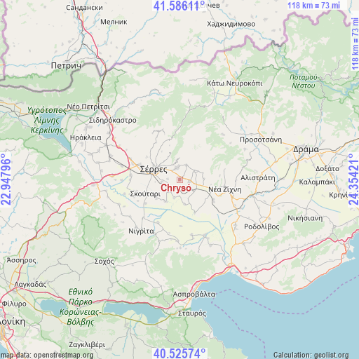
Chrysó GPS coordinates[2]
41° 3' 29.016" North, 23° 39' 3.888" East
| Map corner | latitude | longitude |
|---|---|---|
| Upper-left | 41.58611°, | 22.94796° |
| Center: | 41.05806°, | 23.65108° |
| Lower-right: | 40.52574°, | 24.35421° |
| Map W x H: | 117.9×117.9 km | = 73.3×73.3mi |
| max Lat: | 41.72048° ⇑6% North |
| Chrysó: | 41.05806° |
| min Lat: | ⇓94% South 34.8346° |
| min Long | Chrysó | max Long |
| 19.40494° | 23.65108° | 29.59361° |
| W 68.2%⇐ | ⇒31.8% E |
Elevation
Elevation of Chrysó is 101 m = 331 ft, and this is 67.9 m = 223 ft below average elevation for this country.
| Max E: |
1439 m = 4721 ft | 44.2% |
| Avg. | 168.9 m = 554 ft | |
| Chrysó | 101 m = 331 ft | |
Min E: |
0 m = 0 ft | 55.8% |
See also: Greece elevation on elevation.city.
Geographical zone
Chrysó is located in North temperate zone (between Tropic of Cancer and the Arctic Circle). Distance of this Northern Tropic circle is 1959.3 km =1217.5 mi to South.| Distance of | km | miles | from Chrysó |
|---|---|---|---|
| North Pole | 5441.8 | 3381.4 | to North |
| Arctic Circle | 2835.9 | 1762.1 | to North |
| Tropic Cancer | 1959.3 | 1217.5 | to South |
| Equator | 4565.2 | 2836.7 | to South |


Nearby cities:
15 places around Chrysó: (largest is in red/bold)
• Emmanouíl Pappás
5.8 km =3.6 mi,  58°
58°
• Eptámyloi
6.9 km =4.3 mi,  313°
313°
• Monóvrysi
3.9 km =2.4 mi,  273°
273°
• Neochóri
6 km =3.7 mi,  263°
263°
• Néo Soúli
4 km =2.5 mi,  351°
351°
• Néos Skopós
5.2 km =3.2 mi,  222°
222°
• Oinoússa
5.4 km =3.4 mi,  336°
336°
• Paralímnio
8.3 km =5.2 mi,  168°
168°
• Pentápoli
3.3 km =2.1 mi,  105°
105°
• Psychikó
6.3 km =3.9 mi,  196°
196°
• Sérres
9.2 km =5.7 mi,  289°
289°
• Toúmpa
6 km =3.7 mi,  129°
129°
• Valtotópi
8.5 km =5.3 mi,  212°
212°
• Ágio Pnévma
5.4 km =3.4 mi,  26°
26°
• Ágios Ioánnis
7.5 km =4.7 mi, 307°
Sources, notices
• [Note1] Compared only with cities in Greece existing in our database
• [Src1] Map data: © OpenStreetMap contributors (CC-BY-SA)
• [Src2] Other city data from geonames.org with taken over terms of usage.
• [Src3] Geographical zone / Annual Mean Temperature by Robert A. Rohde @ Wikipedia
