Sérres geodata
Sérres (Central Macedonia) is a seat of a second-order administrative division; located in Greece in Europe/Athens (GMT+3) time zone. With population of 58,287 people, there are 32 cities with bigger population in this country. Compared to other cities in Greece, 94.9% of cities are located further ↓South; 65.5% of cities are located further ←West and 64.1% of cities have higher elevation than Sérres. Note1


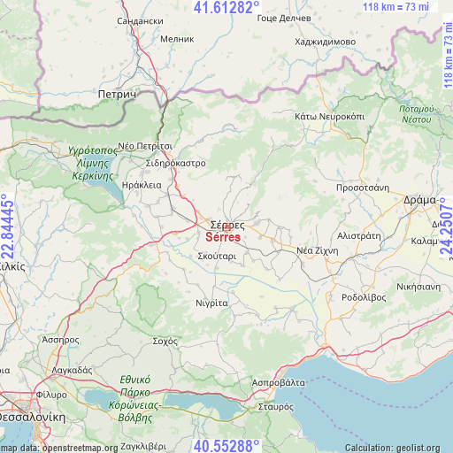
Sérres GPS coordinates[2]
41° 5' 5.964" North, 23° 32' 51.252" East
| Map corner | latitude | longitude |
|---|---|---|
| Upper-left | 41.61282°, | 22.84445° |
| Center: | 41.08499°, | 23.54757° |
| Lower-right: | 40.55288°, | 24.2507° |
| Map W x H: | 117.9×117.9 km | = 73.3×73.3mi |
| max Lat: | 41.72048° ⇑5.1% North |
| Sérres: | 41.08499° |
| min Lat: | ⇓94.9% South 34.8346° |
| min Long | Sérres | max Long |
| 19.40494° | 23.54757° | 29.59361° |
| W 65.5%⇐ | ⇒34.5% E |
Elevation
Elevation of Sérres is 41 m = 135 ft, and this is 127.9 m = 420 ft below average elevation for this country.
| Max E: |
1439 m = 4721 ft | 64.1% |
| Avg. | 168.9 m = 554 ft | |
| Sérres | 41 m = 135 ft | |
Min E: |
0 m = 0 ft | 35.9% |
See also: Sérres elevation on elevation.city.
Geographical zone
Sérres is located in North temperate zone (between Tropic of Cancer and the Arctic Circle). Distance of this Northern Tropic circle is 1962.3 km =1219.3 mi to South.| Distance of | km | miles | from Sérres |
|---|---|---|---|
| North Pole | 5438.8 | 3379.5 | to North |
| Arctic Circle | 2833 | 1760.3 | to North |
| Tropic Cancer | 1962.3 | 1219.3 | to South |
| Equator | 4568.2 | 2838.5 | to South |


Nearby cities:
15 places around Sérres: (largest is in red/bold)
• Chrysó
9.2 km =5.7 mi,  109°
109°
• Eptámyloi
4.1 km =2.5 mi,  64°
64°
• Kalá Déndra
10.5 km =6.5 mi,  278°
278°
• Káto Kamíla
8.9 km =5.5 mi,  217°
217°
• Lefkónas
4.6 km =2.9 mi,  291°
291°
• Mitroúsi
7.5 km =4.7 mi,  257°
257°
• Monóvrysi
5.6 km =3.5 mi,  119°
119°
• Neochóri
4.5 km =2.8 mi,  143°
143°
• Néo Soúli
8.1 km =5 mi,  82°
82°
• Néos Skopós
8.5 km =5.3 mi, 142°
• Oinoússa
6.8 km =4.2 mi,  73°
73°
• Skoútari
7.7 km =4.8 mi,  197°
197°
• Valtotópi
11 km =6.8 mi,  158°
158°
• Ágios Ioánnis
3.2 km =2 mi, 59°
• Áno Kamíla
10.8 km =6.7 mi,  253°
253°
Sources, notices
• [Note1] Compared only with cities in Greece existing in our database
• [Src1] Map data: © OpenStreetMap contributors (CC-BY-SA)
• [Src2] Other city data from geonames.org with taken over terms of usage.
• [Src3] Geographical zone / Annual Mean Temperature by Robert A. Rohde @ Wikipedia
