Fíliro geodata
Fíliro (Central Macedonia) is a populated place; located in Greece in Europe/Athens (GMT+3) time zone. With population of 4,362 people, there are 262 cities with bigger population in this country. Compared to other cities in Greece, 81.3% of cities are located further ↓South; 55.1% of cities are located further ←West and 85.8% of cities have lower elevation than Fíliro. Note1
Administrative division(s):
- Level 1: Central Macedonia
- Level 2: Nomós Thessaloníkis
- Level 3: Dimos Pylaia-Chortiatis


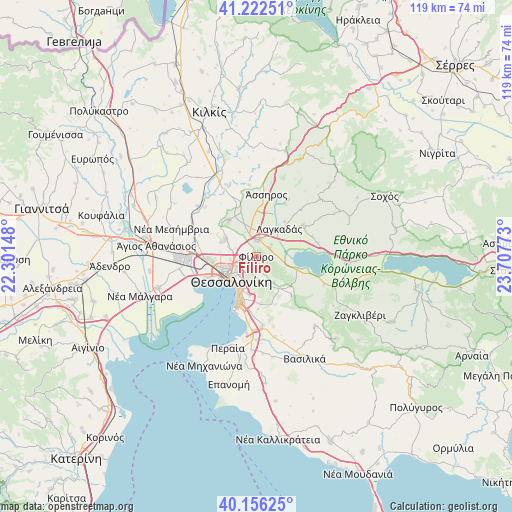
Fíliro GPS coordinates[2]
40° 41' 29.436" North, 23° 0' 16.56" East
| Map corner | latitude | longitude |
|---|---|---|
| Upper-left | 41.22251°, | 22.30148° |
| Center: | 40.69151°, | 23.0046° |
| Lower-right: | 40.15625°, | 23.70773° |
| Map W x H: | 118.6×118.6 km | = 73.7×73.7mi |
| max Lat: | 41.72048° ⇑18.7% North |
| Fíliro: | 40.69151° |
| min Lat: | ⇓81.3% South 34.8346° |
| min Long | Fíliro | max Long |
| 19.40494° | 23.0046° | 29.59361° |
| W 55.1%⇐ | ⇒44.9% E |
Elevation
Elevation of Fíliro is 395 m = 1296 ft, and this is 226.1 m = 742 ft above average elevation for this country.
| Max E: |
1439 m = 4721 ft | 14.2% |
| Fíliro | 395 m 1296 ft | |
| Avg. | 168.9 m = 554 ft | |
Min E: |
0 m = 0 ft | 85.8% |
See also: Greece elevation on elevation.city.
Geographical zone
Fíliro is located in North temperate zone (between Tropic of Cancer and the Arctic Circle). Distance of this Northern Tropic circle is 1918.6 km =1192.2 mi to South.| Distance of | km | miles | from Fíliro |
|---|---|---|---|
| North Pole | 5482.6 | 3406.7 | to North |
| Arctic Circle | 2876.7 | 1787.5 | to North |
| Tropic Cancer | 1918.6 | 1192.2 | to South |
| Equator | 4524.5 | 2811.4 | to South |


Nearby cities:
15 places around Fíliro: (largest is in red/bold)
• Ampelókipoi
7.9 km =4.9 mi,  237°
237°
• Asvestochóri
5.9 km =3.7 mi,  162°
162°
• Efkarpía
4.3 km =2.7 mi,  264°
264°
• Iráklion
7.7 km =4.8 mi,  19°
19°
• Kavallári
4.4 km =2.7 mi,  52°
52°
• Lagyná
3.6 km =2.2 mi,  359°
359°
• Lití
6.3 km =3.9 mi,  340°
340°
• Neapoli
6.8 km =4.2 mi,  231°
231°
• Perivolákion
6.4 km =4 mi, 24°
• Políchni
5.5 km =3.4 mi, 239°
• Péfka
3.8 km =2.4 mi,  193°
193°
• Stavroúpoli
6.1 km =3.8 mi,  246°
246°
• Sykiés
6.5 km =4 mi,  224°
224°
• Thessaloníki
8.2 km =5.1 mi, 229°
• Ágios Pávlos
6.8 km =4.2 mi,  213°
213°
Sources, notices
• [Note1] Compared only with cities in Greece existing in our database
• [Src1] Map data: © OpenStreetMap contributors (CC-BY-SA)
• [Src2] Other city data from geonames.org with taken over terms of usage.
• [Src3] Geographical zone / Annual Mean Temperature by Robert A. Rohde @ Wikipedia
