Asvestochóri geodata
Asvestochóri (Central Macedonia) is a populated place; located in Greece in Europe/Athens (GMT+3) time zone. With population of 6,404 people, there are 197 cities with bigger population in this country. Compared to other cities in Greece, 79.1% of cities are located further ↓South; 55.5% of cities are located further ←West and 84% of cities have lower elevation than Asvestochóri. Note1
Administrative division(s):
- Level 1: Central Macedonia
- Level 2: Nomós Thessaloníkis
- Level 3: Dimos Pylaia-Chortiatis


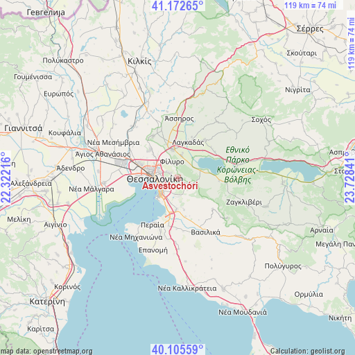
Asvestochóri GPS coordinates[2]
40° 38' 28.5" North, 23° 1' 31.008" East
| Map corner | latitude | longitude |
|---|---|---|
| Upper-left | 41.17265°, | 22.32216° |
| Center: | 40.64125°, | 23.02528° |
| Lower-right: | 40.10559°, | 23.72841° |
| Map W x H: | 118.6×118.6 km | = 73.7×73.7mi |
| max Lat: | 41.72048° ⇑20.9% North |
| Asvestochóri: | 40.64125° |
| min Lat: | ⇓79.1% South 34.8346° |
| min Long | Asvestochóri | max Long |
| 19.40494° | 23.02528° | 29.59361° |
| W 55.5%⇐ | ⇒44.5% E |
Elevation
Elevation of Asvestochóri is 357 m = 1171 ft, and this is 188.1 m = 617 ft above average elevation for this country.
| Max E: |
1439 m = 4721 ft | 16% |
| Asvestochóri | 357 m 1171 ft | |
| Avg. | 168.9 m = 554 ft | |
Min E: |
0 m = 0 ft | 84% |
See also: Greece elevation on elevation.city.
Geographical zone
Asvestochóri is located in North temperate zone (between Tropic of Cancer and the Arctic Circle). Distance of this Northern Tropic circle is 1913 km =1188.7 mi to South.| Distance of | km | miles | from Asvestochóri |
|---|---|---|---|
| North Pole | 5488.2 | 3410.2 | to North |
| Arctic Circle | 2882.3 | 1791 | to North |
| Tropic Cancer | 1913 | 1188.7 | to South |
| Equator | 4518.9 | 2807.9 | to South |


Nearby cities:
15 places around Asvestochóri: (largest is in red/bold)
• Chortiátis
7.2 km =4.5 mi,  119°
119°
• Efkarpía
8 km =5 mi,  310°
310°
• Fíliro
5.9 km =3.7 mi,  342°
342°
• Kavallári
8.4 km =5.2 mi,  11°
11°
• Neapoli
7.2 km =4.5 mi,  280°
280°
• Panórama
6 km =3.7 mi,  174°
174°
• Políchni
7 km =4.3 mi,  293°
293°
• Pylaía
5.7 km =3.5 mi,  215°
215°
• Péfka
3.2 km =2 mi, 305°
• Stavroúpoli
8 km =5 mi, 293°
• Sykiés
6.3 km =3.9 mi, 278°
• Thessaloníki
8 km =5 mi,  271°
271°
• Triandría
5.1 km =3.2 mi,  234°
234°
• Ágios Pávlos
5.5 km =3.4 mi, 269°
• Ágios Vasíleios
7.9 km =4.9 mi,  71°
71°
Sources, notices
• [Note1] Compared only with cities in Greece existing in our database
• [Src1] Map data: © OpenStreetMap contributors (CC-BY-SA)
• [Src2] Other city data from geonames.org with taken over terms of usage.
• [Src3] Geographical zone / Annual Mean Temperature by Robert A. Rohde @ Wikipedia
