Sykiés geodata
Sykiés (Central Macedonia) is a seat of a third-order administrative division; located in Greece in Europe/Athens (GMT+3) time zone. With population of 44,955 people, there are 46 cities with bigger population in this country. Compared to other cities in Greece, 79.4% of cities are located further ↓South; 53.2% of cities are located further ←West and 59.6% of cities have lower elevation than Sykiés. Note1
Administrative division(s):
- Level 1: Central Macedonia
- Level 2: Nomós Thessaloníkis
- Level 3: Dimos Neapoli-Sykies


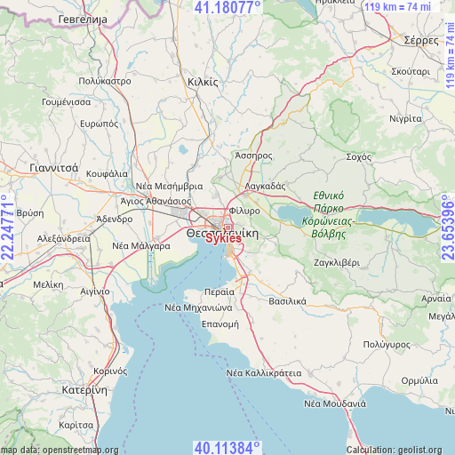
Sykiés GPS coordinates[2]
40° 38' 57.984" North, 22° 57' 2.988" East
| Map corner | latitude | longitude |
|---|---|---|
| Upper-left | 41.18077°, | 22.24771° |
| Center: | 40.64944°, | 22.95083° |
| Lower-right: | 40.11384°, | 23.65396° |
| Map W x H: | 118.6×118.6 km | = 73.7×73.7mi |
| max Lat: | 41.72048° ⇑20.6% North |
| Sykiés: | 40.64944° |
| min Lat: | ⇓79.4% South 34.8346° |
| min Long | Sykiés | max Long |
| 19.40494° | 22.95083° | 29.59361° |
| W 53.2%⇐ | ⇒46.8% E |
Elevation
Elevation of Sykiés is 115 m = 377 ft, and this is 53.9 m = 177 ft below average elevation for this country.
| Max E: |
1439 m = 4721 ft | 40.4% |
| Avg. | 168.9 m = 554 ft | |
| Sykiés | 115 m = 377 ft | |
Min E: |
0 m = 0 ft | 59.6% |
See also: Sykiés elevation on elevation.city.
Geographical zone
Sykiés is located in North temperate zone (between Tropic of Cancer and the Arctic Circle). Distance of this Northern Tropic circle is 1913.9 km =1189.2 mi to South.| Distance of | km | miles | from Sykiés |
|---|---|---|---|
| North Pole | 5487.3 | 3409.6 | to North |
| Arctic Circle | 2881.4 | 1790.4 | to North |
| Tropic Cancer | 1913.9 | 1189.2 | to South |
| Equator | 4519.8 | 2808.5 | to South |


Nearby cities:
15 places around Sykiés: (largest is in red/bold)
• Ampelókipoi
2.1 km =1.3 mi,  280°
280°
• Asvestochóri
6.3 km =3.9 mi,  98°
98°
• Efkarpía
4.3 km =2.7 mi,  2°
2°
• Fíliro
6.5 km =4 mi,  44°
44°
• Kalamariá
7.4 km =4.6 mi,  180°
180°
• Meneméni
4.6 km =2.9 mi, 282°
• Neapoli
0.9 km =0.6 mi,  298°
298°
• Políchni
1.9 km =1.2 mi,  354°
354°
• Pylaía
6.3 km =3.9 mi,  151°
151°
• Péfka
3.7 km =2.3 mi,  75°
75°
• Stavroúpoli
2.5 km =1.6 mi,  334°
334°
• Thessaloníki
1.8 km =1.1 mi,  248°
248°
• Triandría
4.4 km =2.7 mi, 150°
• Ágios Pávlos
1.3 km =0.8 mi,  140°
140°
• Évosmos
4.3 km =2.7 mi, 303°
Sources, notices
• [Note1] Compared only with cities in Greece existing in our database
• [Src1] Map data: © OpenStreetMap contributors (CC-BY-SA)
• [Src2] Other city data from geonames.org with taken over terms of usage.
• [Src3] Geographical zone / Annual Mean Temperature by Robert A. Rohde @ Wikipedia
