Theodorákeio geodata
Theodorákeio (Central Macedonia) is a populated place; located in Greece in Europe/Athens (GMT+3) time zone. With population of 583 people, there are 1618 cities with bigger population in this country. Compared to other cities in Greece, 90.3% of cities are located further ↓South; 67.6% of cities are located further →East and 86.5% of cities have lower elevation than Theodorákeio. Note1


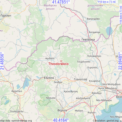
Theodorákeio GPS coordinates[2]
40° 56' 58.524" North, 22° 11' 30.048" East
| Map corner | latitude | longitude |
|---|---|---|
| Upper-left | 41.47851°, | 21.48856° |
| Center: | 40.94959°, | 22.19168° |
| Lower-right: | 40.4164°, | 22.89481° |
| Map W x H: | 118.1×118.1 km | = 73.4×73.4mi |
| max Lat: | 41.72048° ⇑9.7% North |
| Theodorákeio: | 40.94959° |
| min Lat: | ⇓90.3% South 34.8346° |
| min Long | Theodorákeio | max Long |
| 19.40494° | 22.19168° | 29.59361° |
| W 32.4%⇐ | ⇒67.6% E |
Elevation
Elevation of Theodorákeio is 422 m = 1385 ft, and this is 253.1 m = 830 ft above average elevation for this country.
| Max E: |
1439 m = 4721 ft | 13.5% |
| Theodorákeio | 422 m 1385 ft | |
| Avg. | 168.9 m = 554 ft | |
Min E: |
0 m = 0 ft | 86.5% |
See also: Greece elevation on elevation.city.
Geographical zone
Theodorákeio is located in North temperate zone (between Tropic of Cancer and the Arctic Circle). Distance of this Northern Tropic circle is 1947.2 km =1209.9 mi to South.| Distance of | km | miles | from Theodorákeio |
|---|---|---|---|
| North Pole | 5453.9 | 3388.9 | to North |
| Arctic Circle | 2848 | 1769.7 | to North |
| Tropic Cancer | 1947.2 | 1209.9 | to South |
| Equator | 4553.2 | 2829.2 | to South |


Nearby cities:
15 places around Theodorákeio: (largest is in red/bold)
• Aridaía
11.7 km =7.3 mi,  282°
282°
• Dorothéa
12.3 km =7.6 mi,  293°
293°
• Droseró
14.9 km =9.3 mi,  161°
161°
• Exaplátanos
6 km =3.7 mi,  299°
299°
• Filóteia
10 km =6.2 mi,  340°
340°
• Kalí
14.5 km =9 mi,  184°
184°
• Konstantía
5.7 km =3.5 mi, 344°
• Miliá
6.2 km =3.9 mi,  320°
320°
• Mándalo
10.5 km =6.5 mi,  170°
170°
• Sosándra
14.4 km =8.9 mi, 292°
• Tsákoi
13 km =8.1 mi,  272°
272°
• Voreinó
12.9 km =8 mi,  312°
312°
• Xifianí
9.6 km =6 mi,  256°
256°
• Ápsalos
13 km =8.1 mi,  240°
240°
• Ída
6.8 km =4.2 mi,  349°
349°
Sources, notices
• [Note1] Compared only with cities in Greece existing in our database
• [Src1] Map data: © OpenStreetMap contributors (CC-BY-SA)
• [Src2] Other city data from geonames.org with taken over terms of usage.
• [Src3] Geographical zone / Annual Mean Temperature by Robert A. Rohde @ Wikipedia
