Moyuta geodata
Moyuta (Jutiapa) is a seat of a second-order administrative division; located in Guatemala in America/Guatemala (GMT-6) time zone. With population of 8,145 people, there are 154 cities with bigger population in this country. Compared to other cities in Guatemala, 99.1% of cities are located further ↑North; 79.1% of cities are located further ←West and 51.6% of cities have lower elevation than Moyuta. Note1


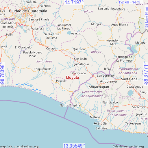
Moyuta GPS coordinates[2]
14° 2' 18.996" North, 90° 4' 50.988" West
| Map corner | latitude | longitude |
|---|---|---|
| Upper-left | 14.7197°, | -90.78396° |
| Center: | 14.03861°, | -90.08083° |
| Lower-right: | 13.35549°, | -89.37771° |
| Map W x H: | 151.7×151.7 km | = 94.3×94.3mi |
| max Lat: | 17.06606° ⇑99.1% North |
| Moyuta: | 14.03861° |
| min Lat: | ⇓0.9% South 13.9274° |
| min Long | Moyuta | max Long |
| -92.19298° | -90.08083° | -88.59444° |
| W 79.1%⇐ | ⇒20.9% E |
Elevation
Elevation of Moyuta is 1285 m = 4216 ft, and this is 18 m = 59 ft above average elevation for this country.
| Max E: |
3254 m = 10676 ft | 48.4% |
| Moyuta | 1285 m 4216 ft | |
| Avg. | 1267 m = 4157 ft | |
Min E: |
1 m = 3 ft | 51.6% |
See also: Guatemala elevation on elevation.city.
Geographical zone
Moyuta is located in North Torrid zone (between Equator and Tropic of Cancer). Distance of this Northern Tropic circle is 1045 km =649.3 mi to North.| Distance of | km | miles | from Moyuta |
|---|---|---|---|
| North Pole | 8446.1 | 5248.2 | to North |
| Arctic Circle | 5840.2 | 3628.9 | to North |
| Tropic Cancer | 1045 | 649.3 | to North |
| Equator | 1560.9 | 969.9 | to South |


Nearby cities:
15 places around Moyuta: (largest is in red/bold)
• Chiquimulilla
33.2 km =20.6 mi,  278°
278°
• Comapa
19.7 km =12.2 mi,  63°
63°
• Conguaco
5.4 km =3.4 mi,  83°
83°
• Cuilapa
35.4 km =22 mi,  318°
318°
• El Adelanto
30.3 km =18.8 mi, 61°
• Jalpatagua
13.9 km =8.6 mi,  34°
34°
• Jerez
36.3 km =22.6 mi, 79°
• Jutiapa
34.5 km =21.4 mi,  35°
35°
• Oratorio
23.4 km =14.5 mi,  334°
334°
• Pasaco
15.2 km =9.4 mi,  243°
243°
• Quesada
26.1 km =16.2 mi,  9°
9°
• San José Acatempa
25.7 km =16 mi,  348°
348°
• San Juan Tecuaco
20.6 km =12.8 mi, 284°
• Santa María Ixhuatán
26.8 km =16.7 mi,  308°
308°
• Zapotitlán
28.7 km =17.8 mi,  68°
68°
Sources, notices
• [Note1] Compared only with cities in Guatemala existing in our database
• [Src1] Map data: © OpenStreetMap contributors (CC-BY-SA)
• [Src2] Other city data from geonames.org with taken over terms of usage.
• [Src3] Geographical zone / Annual Mean Temperature by Robert A. Rohde @ Wikipedia
