San José Acatempa geodata
San José Acatempa (Jutiapa) is a seat of a second-order administrative division; located in Guatemala in America/Guatemala (GMT-6) time zone. With population of 6,367 people, there are 182 cities with bigger population in this country. Compared to other cities in Guatemala, 92.9% of cities are located further ↑North; 78.2% of cities are located further ←West and 53.4% of cities have lower elevation than San José Acatempa. Note1


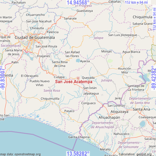
San José Acatempa GPS coordinates[2]
14° 15' 55.008" North, 90° 7' 36.984" West
| Map corner | latitude | longitude |
|---|---|---|
| Upper-left | 14.94568°, | -90.83007° |
| Center: | 14.26528°, | -90.12694° |
| Lower-right: | 13.58282°, | -89.42382° |
| Map W x H: | 151.5×151.5 km | = 94.1×94.1mi |
| max Lat: | 17.06606° ⇑92.9% North |
| San José Acatempa: | 14.26528° |
| min Lat: | ⇓7.1% South 13.9274° |
| min Long | San José Acate | max Long |
| -92.19298° | -90.12694° | -88.59444° |
| W 78.2%⇐ | ⇒21.8% E |
Elevation
Elevation of San José Acatempa is 1346 m = 4416 ft, and this is 79 m = 259 ft above average elevation for this country.
| Max E: |
3254 m = 10676 ft | 46.6% |
| San José Acatempa | 1346 m 4416 ft | |
| Avg. | 1267 m = 4157 ft | |
Min E: |
1 m = 3 ft | 53.4% |
See also: Guatemala elevation on elevation.city.
Geographical zone
San José Acatempa is located in North Torrid zone (between Equator and Tropic of Cancer). Distance of this Northern Tropic circle is 1019.8 km =633.7 mi to North.| Distance of | km | miles | from San José Acatempa |
|---|---|---|---|
| North Pole | 8420.9 | 5232.5 | to North |
| Arctic Circle | 5815 | 3613.3 | to North |
| Tropic Cancer | 1019.8 | 633.7 | to North |
| Equator | 1586.2 | 985.6 | to South |


Nearby cities:
15 places around San José Acatempa: (largest is in red/bold)
• Barberena
25.7 km =16 mi,  280°
280°
• Casillas
21.2 km =13.2 mi,  323°
323°
• Conguaco
26.7 km =16.6 mi,  157°
157°
• Cuilapa
18.6 km =11.6 mi,  273°
273°
• Jalpatagua
18.8 km =11.7 mi,  137°
137°
• Jutiapa
25.1 km =15.6 mi,  83°
83°
• Moyuta
25.7 km =16 mi,  168°
168°
• Nueva Santa Rosa
20.6 km =12.8 mi,  308°
308°
• Oratorio
6.7 km =4.2 mi,  231°
231°
• Quesada
9.4 km =5.8 mi,  86°
86°
• San Carlos Alzatate
26.8 km =16.7 mi,  15°
15°
• San Juan Tecuaco
25.2 km =15.7 mi,  216°
216°
• San Rafael Las Flores
24.1 km =15 mi,  346°
346°
• Santa María Ixhuatán
18 km =11.2 mi,  242°
242°
• Santa Rosa de Lima
22.7 km =14.1 mi, 306°
Sources, notices
• [Note1] Compared only with cities in Guatemala existing in our database
• [Src1] Map data: © OpenStreetMap contributors (CC-BY-SA)
• [Src2] Other city data from geonames.org with taken over terms of usage.
• [Src3] Geographical zone / Annual Mean Temperature by Robert A. Rohde @ Wikipedia
