Mangilao Village geodata
Mangilao Village (Mangilao) is a seat of a first-order administrative division; located in Guam in Pacific/Guam (GMT+10) time zone. With population of 15,191 people, there are 4 cities with bigger population in this country. Compared to other cities in Guam, 61.9% of cities are located further ↑North; 90.5% of cities are located further ←West and 71.4% of cities have lower elevation than Mangilao Village. Note1


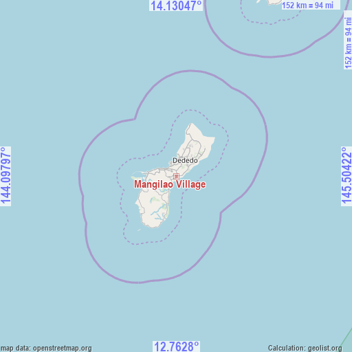
Mangilao Village GPS coordinates[2]
13° 26' 51.396" North, 144° 48' 3.924" East
| Map corner | latitude | longitude |
|---|---|---|
| Upper-left | 14.13047°, | 144.09797° |
| Center: | 13.44761°, | 144.80109° |
| Lower-right: | 12.7628°, | 145.50422° |
| Map W x H: | 152.1×152.1 km | = 94.5×94.5mi |
| max Lat: | 13.53605° ⇑61.9% North |
| Mangilao Village: | 13.44761° |
| min Lat: | ⇓38.1% South 13.26584° |
| min Long | Mangilao Villag | max Long |
| 144.65852° | 144.80109° | 144.88855° |
| W 90.5%⇐ | ⇒9.5% E |
Elevation
Elevation of Mangilao Village is 58 m = 190 ft, and this is 14.8 m = 49 ft above average elevation for this country.
| Max E: |
132 m = 433 ft | 28.6% |
| Mangilao Village | 58 m 190 ft | |
| Avg. | 43.2 m = 142 ft | |
Min E: |
0 m = 0 ft | 71.4% |
See also: Guam elevation on elevation.city.
Geographical zone
Mangilao Village is located in North Torrid zone (between Equator and Tropic of Cancer). Distance of this Northern Tropic circle is 1110.7 km =690.2 mi to North.| Distance of | km | miles | from Mangilao Village |
|---|---|---|---|
| North Pole | 8511.8 | 5289 | to North |
| Arctic Circle | 5905.9 | 3669.8 | to North |
| Tropic Cancer | 1110.7 | 690.2 | to North |
| Equator | 1495.2 | 929.1 | to South |


Nearby cities:
15 places around Mangilao Village: (largest is in red/bold)
• Agana Heights Village
6.1 km =3.8 mi,  289°
289°
• Asan-Maina Village
9.5 km =5.9 mi, 286°
• Barrigada Village
2.4 km =1.5 mi,  354°
354°
• Chalan Pago-Ordot Village
4.5 km =2.8 mi,  269°
269°
• Dededo Village
8.8 km =5.5 mi,  27°
27°
• Guam Government House
6.2 km =3.9 mi,  295°
295°
• Hagåtña
6.5 km =4 mi, 298°
• Hagåtña Village
5.4 km =3.4 mi, 301°
• Mongmong-Toto-Maite Village
3.1 km =1.9 mi,  318°
318°
• Piti Village
11.8 km =7.3 mi,  278°
278°
• Sinajana Village
5.4 km =3.4 mi, 288°
• Talofofo Village
11.3 km =7 mi,  204°
204°
• Tamuning
4.9 km =3 mi,  334°
334°
• Tamuning-Tumon-Harmon Village
4.9 km =3 mi, 334°
• Yona Village
5 km =3.1 mi,  211°
211°
Sources, notices
• [Note1] Compared only with cities in Guam existing in our database
• [Src1] Map data: © OpenStreetMap contributors (CC-BY-SA)
• [Src2] Other city data from geonames.org with taken over terms of usage.
• [Src3] Geographical zone / Annual Mean Temperature by Robert A. Rohde @ Wikipedia
