Zambrano geodata
Zambrano (Francisco Morazán) is a populated place; located in Honduras in America/Tegucigalpa (GMT-6) time zone. With population of 3,873 people, there are 82 cities with bigger population in this country. Compared to other cities in Honduras, 79% of cities are located further ↑North; 57.6% of cities are located further ←West and 96% of cities have lower elevation than Zambrano. Note1


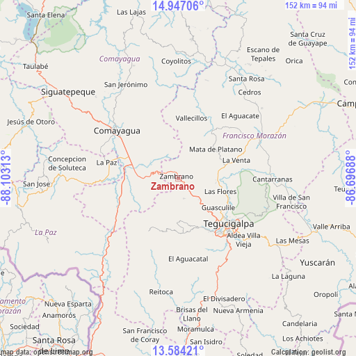
Zambrano GPS coordinates[2]
14° 16' 0.012" North, 87° 24' 0" West
| Map corner | latitude | longitude |
|---|---|---|
| Upper-left | 14.94706°, | -88.10313° |
| Center: | 14.26667°, | -87.4° |
| Lower-right: | 13.58421°, | -86.69688° |
| Map W x H: | 151.5×151.5 km | = 94.1×94.1mi |
| max Lat: | 16.45° ⇑79% North |
| Zambrano: | 14.26667° |
| min Lat: | ⇓21% South 13.11667° |
| min Long | Zambrano | max Long |
| -89.23333° | -87.4° | -83.23333° |
| W 57.6%⇐ | ⇒42.4% E |
Elevation
Elevation of Zambrano is 1358 m = 4455 ft, and this is 796.8 m = 2614 ft above average elevation for this country.
| Max E: |
1811 m = 5942 ft | 4% |
| Zambrano | 1358 m 4455 ft | |
| Avg. | 561.2 m = 1841 ft | |
Min E: |
1 m = 3 ft | 96% |
See also: Honduras elevation on elevation.city.
Geographical zone
Zambrano is located in North Torrid zone (between Equator and Tropic of Cancer). Distance of this Northern Tropic circle is 1019.6 km =633.5 mi to North.| Distance of | km | miles | from Zambrano |
|---|---|---|---|
| North Pole | 8420.8 | 5232.4 | to North |
| Arctic Circle | 5814.9 | 3613.2 | to North |
| Tropic Cancer | 1019.6 | 633.5 | to North |
| Equator | 1586.3 | 985.7 | to South |


Nearby cities:
15 places around Zambrano: (largest is in red/bold)
• Agalteca
24.9 km =15.5 mi,  35°
35°
• Cofradía
24 km =14.9 mi,  103°
103°
• El Durazno
20.6 km =12.8 mi,  135°
135°
• El Lolo
22 km =13.7 mi, 139°
• Flores
18.1 km =11.2 mi,  275°
275°
• Lamaní
24.5 km =15.2 mi,  252°
252°
• Las Mercedes
18.1 km =11.2 mi, 275°
• Las Tapias
25.5 km =15.8 mi,  150°
150°
• Lepaterique
23.4 km =14.5 mi,  197°
197°
• Mateo
22.3 km =13.9 mi,  156°
156°
• Pueblo Nuevo
18.1 km =11.2 mi, 44°
• Río Abajo
22.7 km =14.1 mi,  119°
119°
• San Sebastián
25.2 km =15.7 mi,  265°
265°
• Támara
14.8 km =9.2 mi, 151°
• Villa de San Antonio
24 km =14.9 mi, 283°
Sources, notices
• [Note1] Compared only with cities in Honduras existing in our database
• [Src1] Map data: © OpenStreetMap contributors (CC-BY-SA)
• [Src2] Other city data from geonames.org with taken over terms of usage.
• [Src3] Geographical zone / Annual Mean Temperature by Robert A. Rohde @ Wikipedia
