San Francisco del Valle geodata
San Francisco del Valle (Ocotepeque) is a populated place; located in Honduras in America/Tegucigalpa (GMT-6) time zone. With population of 1,878 people, there are 195 cities with bigger population in this country. Compared to other cities in Honduras, 73.8% of cities are located further ↑North; 95.8% of cities are located further →East and 78.2% of cities have lower elevation than San Francisco del Valle. Note1
Current local time in San Francisco del Valle:
07:34 PM, SundayDifference from your time zone: hours


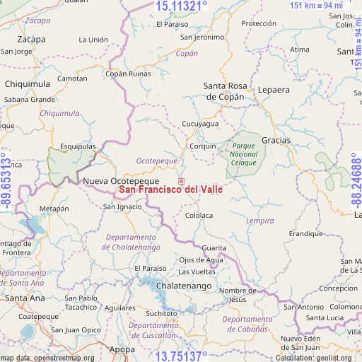
San Francisco del Valle GPS coordinates[2]
14° 25' 59.988" North, 88° 57' 0" West
| Map corner | latitude | longitude |
|---|---|---|
| Upper-left | 15.11321°, | -89.65313° |
| Center: | 14.43333°, | -88.95° |
| Lower-right: | 13.75137°, | -88.24688° |
| Map W x H: | 151.4×151.4 km | = 94.1×94.1mi |
| max Lat: | 16.45° ⇑73.8% North |
| San Francisco del Valle: | 14.43333° |
| min Lat: | ⇓26.2% South 13.11667° |
| min Long | San Francisco d | max Long |
| -89.23333° | -88.95° | -83.23333° |
| W 4.2%⇐ | ⇒95.8% E |
Elevation
Elevation of San Francisco del Valle is 899 m = 2949 ft, and this is 337.8 m = 1108 ft above average elevation for this country.
| Max E: |
1811 m = 5942 ft | 21.8% |
| San Francisco del Valle | 899 m 2949 ft | |
| Avg. | 561.2 m = 1841 ft | |
Min E: |
1 m = 3 ft | 78.2% |
See also: Honduras elevation on elevation.city.
Geographical zone
San Francisco del Valle is located in North Torrid zone (between Equator and Tropic of Cancer). Distance of this Northern Tropic circle is 1001.1 km =622.1 mi to North.| Distance of | km | miles | from San Francisco del Valle |
|---|---|---|---|
| North Pole | 8402.2 | 5220.9 | to North |
| Arctic Circle | 5796.3 | 3601.7 | to North |
| Tropic Cancer | 1001.1 | 622.1 | to North |
| Equator | 1604.8 | 997.2 | to South |


Nearby cities:
15 places around San Francisco del Valle: (largest is in red/bold)
• Belén Gualcho
17.1 km =10.6 mi,  71°
71°
• Cololaca
16.5 km =10.3 mi,  154°
154°
• Corquín
17.3 km =10.7 mi,  31°
31°
• El Granzal
9.7 km =6 mi,  112°
112°
• El Tránsito
6.6 km =4.1 mi, 147°
• La Labor
7.7 km =4.8 mi,  315°
315°
• Llano Largo
8.1 km =5 mi,  297°
297°
• Lucerna
13.1 km =8.1 mi,  7°
7°
• Mercedes
21.5 km =13.4 mi,  270°
270°
• San Antonio
9.4 km =5.8 mi,  349°
349°
• San Francisco de Cones
10.7 km =6.6 mi, 30°
• San Marcos
3.7 km =2.3 mi,  180°
180°
• Santa Teresa
7.7 km =4.8 mi,  224°
224°
• Sensenti
5.8 km =3.6 mi,  17°
17°
• Yaruchel
18.2 km =11.3 mi,  52°
52°
Sources, notices
• [Note1] Compared only with cities in Honduras existing in our database
• [Src1] Map data: © OpenStreetMap contributors (CC-BY-SA)
• [Src2] Other city data from geonames.org with taken over terms of usage.
• [Src3] Geographical zone / Annual Mean Temperature by Robert A. Rohde @ Wikipedia
