Mercedes geodata
Mercedes (Ocotepeque) is a populated place; located in Honduras in America/Tegucigalpa (GMT-6) time zone. With population of 984 people, there are 425 cities with bigger population in this country. Compared to other cities in Honduras, 73.8% of cities are located further ↑North; 98.8% of cities are located further →East and 97% of cities have lower elevation than Mercedes. Note1


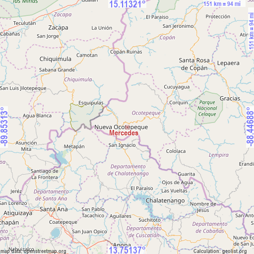
Mercedes GPS coordinates[2]
14° 25' 59.988" North, 89° 9' 0" West
| Map corner | latitude | longitude |
|---|---|---|
| Upper-left | 15.11321°, | -89.85313° |
| Center: | 14.43333°, | -89.15° |
| Lower-right: | 13.75137°, | -88.44688° |
| Map W x H: | 151.4×151.4 km | = 94.1×94.1mi |
| max Lat: | 16.45° ⇑73.8% North |
| Mercedes: | 14.43333° |
| min Lat: | ⇓26.2% South 13.11667° |
| min Long | Mercedes | max Long |
| -89.23333° | -89.15° | -83.23333° |
| W 1.2%⇐ | ⇒98.8% E |
Elevation
Elevation of Mercedes is 1402 m = 4600 ft, and this is 840.8 m = 2759 ft above average elevation for this country.
| Max E: |
1811 m = 5942 ft | 3% |
| Mercedes | 1402 m 4600 ft | |
| Avg. | 561.2 m = 1841 ft | |
Min E: |
1 m = 3 ft | 97% |
See also: Honduras elevation on elevation.city.
Geographical zone
Mercedes is located in North Torrid zone (between Equator and Tropic of Cancer). Distance of this Northern Tropic circle is 1001.1 km =622.1 mi to North.| Distance of | km | miles | from Mercedes |
|---|---|---|---|
| North Pole | 8402.2 | 5220.9 | to North |
| Arctic Circle | 5796.3 | 3601.7 | to North |
| Tropic Cancer | 1001.1 | 622.1 | to North |
| Equator | 1604.8 | 997.2 | to South |


Nearby cities:
15 places around Mercedes: (largest is in red/bold)
• Antigua Ocotepeque
6.5 km =4 mi,  235°
235°
• El Tránsito
25.7 km =16 mi,  102°
102°
• La Encarnación
26.9 km =16.7 mi,  15°
15°
• La Labor
17.1 km =10.6 mi,  71°
71°
• Llano Largo
14.8 km =9.2 mi,  75°
75°
• Lucerna
26.7 km =16.6 mi,  60°
60°
• Nueva Ocotepeque
3.6 km =2.2 mi,  270°
270°
• San Antonio
21.8 km =13.5 mi, 64°
• San Francisco del Valle
21.5 km =13.4 mi,  90°
90°
• San Marcos
21.9 km =13.6 mi, 99°
• Santa Fe
12.9 km =8 mi,  315°
315°
• Santa Lucía
5.7 km =3.5 mi,  251°
251°
• Santa Teresa
17.1 km =10.6 mi,  108°
108°
• Sensenti
24 km =14.9 mi, 76°
• Sinuapa
4 km =2.5 mi,  297°
297°
Sources, notices
• [Note1] Compared only with cities in Honduras existing in our database
• [Src1] Map data: © OpenStreetMap contributors (CC-BY-SA)
• [Src2] Other city data from geonames.org with taken over terms of usage.
• [Src3] Geographical zone / Annual Mean Temperature by Robert A. Rohde @ Wikipedia
