Yaruchel geodata
Yaruchel (Ocotepeque) is a populated place; located in Honduras in America/Tegucigalpa (GMT-6) time zone. With population of 1,105 people, there are 355 cities with bigger population in this country. Compared to other cities in Honduras, 69.2% of cities are located further ↑North; 91.8% of cities are located further →East and 96.4% of cities have lower elevation than Yaruchel. Note1


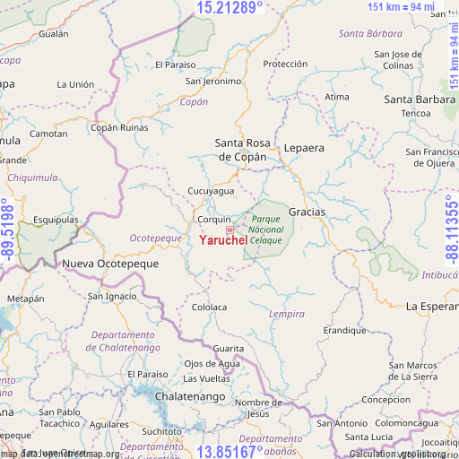
Yaruchel GPS coordinates[2]
14° 31' 59.988" North, 88° 49' 0.012" West
| Map corner | latitude | longitude |
|---|---|---|
| Upper-left | 15.21289°, | -89.5198° |
| Center: | 14.53333°, | -88.81667° |
| Lower-right: | 13.85167°, | -88.11355° |
| Map W x H: | 151.4×151.4 km | = 94.1×94.1mi |
| max Lat: | 16.45° ⇑69.2% North |
| Yaruchel: | 14.53333° |
| min Lat: | ⇓30.8% South 13.11667° |
| min Long | Yaruchel | max Long |
| -89.23333° | -88.81667° | -83.23333° |
| W 8.2%⇐ | ⇒91.8% E |
Elevation
Elevation of Yaruchel is 1374 m = 4508 ft, and this is 812.8 m = 2667 ft above average elevation for this country.
| Max E: |
1811 m = 5942 ft | 3.6% |
| Yaruchel | 1374 m 4508 ft | |
| Avg. | 561.2 m = 1841 ft | |
Min E: |
1 m = 3 ft | 96.4% |
See also: Honduras elevation on elevation.city.
Geographical zone
Yaruchel is located in North Torrid zone (between Equator and Tropic of Cancer). Distance of this Northern Tropic circle is 990 km =615.2 mi to North.| Distance of | km | miles | from Yaruchel |
|---|---|---|---|
| North Pole | 8391.1 | 5214 | to North |
| Arctic Circle | 5785.2 | 3594.8 | to North |
| Tropic Cancer | 990 | 615.2 | to North |
| Equator | 1616 | 1004.1 | to South |


Nearby cities:
15 places around Yaruchel: (largest is in red/bold)
• Belén Gualcho
5.8 km =3.6 mi,  162°
162°
• Corquín
6.5 km =4 mi,  304°
304°
• Cucuyagua
14 km =8.7 mi,  337°
337°
• El Corpus
21.4 km =13.3 mi,  329°
329°
• El Granzal
15.8 km =9.8 mi,  199°
199°
• El Tránsito
19.9 km =12.4 mi,  212°
212°
• La Labor
20.5 km =12.7 mi,  254°
254°
• Los Arroyos
14.8 km =9.2 mi, 331°
• Lucerna
12.7 km =7.9 mi,  278°
278°
• Ojos de Agua
18.5 km =11.5 mi,  0°
0°
• San Antonio
16.3 km =10.1 mi,  263°
263°
• San Francisco de Cones
9.2 km =5.7 mi, 258°
• San Francisco del Valle
18.2 km =11.3 mi,  232°
232°
• San Marcos
20.6 km =12.8 mi,  224°
224°
• Sensenti
13.7 km =8.5 mi, 246°
Sources, notices
• [Note1] Compared only with cities in Honduras existing in our database
• [Src1] Map data: © OpenStreetMap contributors (CC-BY-SA)
• [Src2] Other city data from geonames.org with taken over terms of usage.
• [Src3] Geographical zone / Annual Mean Temperature by Robert A. Rohde @ Wikipedia
