La Esperanza geodata
La Esperanza (Copán) is a populated place; located in Honduras in America/Tegucigalpa (GMT-6) time zone. With population of 919 people, there are 467 cities with bigger population in this country. Compared to other cities in Honduras, 62% of cities are located further ↓South; 97.6% of cities are located further →East and 70.4% of cities have lower elevation than La Esperanza. Note1


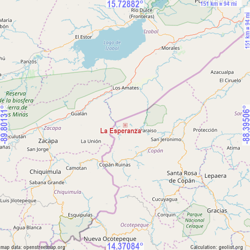
La Esperanza GPS coordinates[2]
15° 3' 3.276" North, 89° 5' 53.448" West
| Map corner | latitude | longitude |
|---|---|---|
| Upper-left | 15.72882°, | -89.80131° |
| Center: | 15.05091°, | -89.09818° |
| Lower-right: | 14.37084°, | -88.39506° |
| Map W x H: | 151×151 km | = 93.8×93.8mi |
| max Lat: | 16.45° ⇑38% North |
| La Esperanza: | 15.05091° |
| min Lat: | ⇓62% South 13.11667° |
| min Long | La Esperanza | max Long |
| -89.23333° | -89.09818° | -83.23333° |
| W 2.4%⇐ | ⇒97.6% E |
Elevation
Elevation of La Esperanza is 775 m = 2543 ft, and this is 213.8 m = 701 ft above average elevation for this country.
| Max E: |
1811 m = 5942 ft | 29.6% |
| La Esperanza | 775 m 2543 ft | |
| Avg. | 561.2 m = 1841 ft | |
Min E: |
1 m = 3 ft | 70.4% |
See also: Honduras elevation on elevation.city.
Geographical zone
La Esperanza is located in North Torrid zone (between Equator and Tropic of Cancer). Distance of this Northern Tropic circle is 932.4 km =579.4 mi to North.| Distance of | km | miles | from La Esperanza |
|---|---|---|---|
| North Pole | 8333.6 | 5178.3 | to North |
| Arctic Circle | 5727.7 | 3559 | to North |
| Tropic Cancer | 932.4 | 579.4 | to North |
| Equator | 1673.5 | 1039.9 | to South |


Nearby cities:
15 places around La Esperanza: (largest is in red/bold)
• Buenos Aires
14.3 km =8.9 mi,  97°
97°
• Copán
24.8 km =15.4 mi,  192°
192°
• Dolores
35.1 km =21.8 mi,  125°
125°
• El Ocotón
23.2 km =14.4 mi,  94°
94°
• Florida
28.5 km =17.7 mi, 93°
• La Jigua
32.1 km =19.9 mi, 93°
• La Playona
14.3 km =8.9 mi,  59°
59°
• La Zumbadora
21.6 km =13.4 mi, 100°
• Nueva Armenia
2 km =1.2 mi, 185°
• Ostumán
25.3 km =15.7 mi,  196°
196°
• Río Amarillo
10.1 km =6.3 mi, 201°
• San Agustín
31.5 km =19.6 mi,  145°
145°
• San Jerónimo
26.6 km =16.5 mi,  110°
110°
• San Joaquín
21.3 km =13.2 mi, 90°
• Santa Rita, Copan
20.4 km =12.7 mi,  180°
180°
Sources, notices
• [Note1] Compared only with cities in Honduras existing in our database
• [Src1] Map data: © OpenStreetMap contributors (CC-BY-SA)
• [Src2] Other city data from geonames.org with taken over terms of usage.
• [Src3] Geographical zone / Annual Mean Temperature by Robert A. Rohde @ Wikipedia
