Dolores geodata
Dolores (Copán) is a populated place; located in Honduras in America/Tegucigalpa (GMT-6) time zone. With population of 1,107 people, there are 353 cities with bigger population in this country. Compared to other cities in Honduras, 51.2% of cities are located further ↑North; 92.4% of cities are located further →East and 91.2% of cities have lower elevation than Dolores. Note1


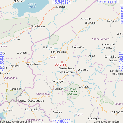
Dolores GPS coordinates[2]
14° 52' 0.012" North, 88° 49' 59.988" West
| Map corner | latitude | longitude |
|---|---|---|
| Upper-left | 15.54517°, | -89.53646° |
| Center: | 14.86667°, | -88.83333° |
| Lower-right: | 14.18603°, | -88.13021° |
| Map W x H: | 151.1×151.1 km | = 93.9×93.9mi |
| max Lat: | 16.45° ⇑51.2% North |
| Dolores: | 14.86667° |
| min Lat: | ⇓48.8% South 13.11667° |
| min Long | Dolores | max Long |
| -89.23333° | -88.83333° | -83.23333° |
| W 7.6%⇐ | ⇒92.4% E |
Elevation
Elevation of Dolores is 1202 m = 3944 ft, and this is 640.8 m = 2102 ft above average elevation for this country.
| Max E: |
1811 m = 5942 ft | 8.8% |
| Dolores | 1202 m 3944 ft | |
| Avg. | 561.2 m = 1841 ft | |
Min E: |
1 m = 3 ft | 91.2% |
See also: Honduras elevation on elevation.city.
Geographical zone
Dolores is located in North Torrid zone (between Equator and Tropic of Cancer). Distance of this Northern Tropic circle is 952.9 km =592.1 mi to North.| Distance of | km | miles | from Dolores |
|---|---|---|---|
| North Pole | 8354 | 5190.9 | to North |
| Arctic Circle | 5748.2 | 3571.8 | to North |
| Tropic Cancer | 952.9 | 592.1 | to North |
| Equator | 1653 | 1027.1 | to South |


Nearby cities:
15 places around Dolores: (largest is in red/bold)
• Agua Caliente
2.6 km =1.6 mi,  44°
44°
• Dulce Nombre
1.9 km =1.2 mi,  180°
180°
• El Derrumbo
14 km =8.7 mi,  157°
157°
• Pueblo Nuevo
17.3 km =10.7 mi,  31°
31°
• Quezailica
10.9 km =6.8 mi,  80°
80°
• San Agustín
12.1 km =7.5 mi,  242°
242°
• San Jerónimo
11.7 km =7.3 mi,  342°
342°
• San José de Copán
13.1 km =8.1 mi,  73°
73°
• San Juan de Opoa
17.1 km =10.6 mi,  122°
122°
• San Juan de Planes
9.2 km =5.7 mi, 35°
• San Nicolás
17.3 km =10.7 mi, 31°
• Santa Rosa de Copán
12.6 km =7.8 mi,  152°
152°
• Trinidad de Copán
12.9 km =8 mi, 44°
• Veracruz
7.7 km =4.8 mi, 44°
• Vivistorio
11.4 km =7.1 mi, 70°
Sources, notices
• [Note1] Compared only with cities in Honduras existing in our database
• [Src1] Map data: © OpenStreetMap contributors (CC-BY-SA)
• [Src2] Other city data from geonames.org with taken over terms of usage.
• [Src3] Geographical zone / Annual Mean Temperature by Robert A. Rohde @ Wikipedia
