Cucuyagua geodata
Cucuyagua (Copán) is a populated place; located in Honduras in America/Tegucigalpa (GMT-6) time zone. With population of 2,939 people, there are 116 cities with bigger population in this country. Compared to other cities in Honduras, 64% of cities are located further ↑North; 93.2% of cities are located further →East and 70.4% of cities have lower elevation than Cucuyagua. Note1


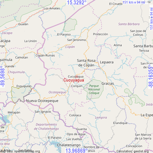
Cucuyagua GPS coordinates[2]
14° 39' 0" North, 88° 52' 0.012" West
| Map corner | latitude | longitude |
|---|---|---|
| Upper-left | 15.3292°, | -89.5698° |
| Center: | 14.65°, | -88.86667° |
| Lower-right: | 13.96869°, | -88.16355° |
| Map W x H: | 151.3×151.3 km | = 94×94mi |
| max Lat: | 16.45° ⇑64% North |
| Cucuyagua: | 14.65° |
| min Lat: | ⇓36% South 13.11667° |
| min Long | Cucuyagua | max Long |
| -89.23333° | -88.86667° | -83.23333° |
| W 6.8%⇐ | ⇒93.2% E |
Elevation
Elevation of Cucuyagua is 775 m = 2543 ft, and this is 213.8 m = 701 ft above average elevation for this country.
| Max E: |
1811 m = 5942 ft | 29.6% |
| Cucuyagua | 775 m 2543 ft | |
| Avg. | 561.2 m = 1841 ft | |
Min E: |
1 m = 3 ft | 70.4% |
See also: Honduras elevation on elevation.city.
Geographical zone
Cucuyagua is located in North Torrid zone (between Equator and Tropic of Cancer). Distance of this Northern Tropic circle is 977 km =607.1 mi to North.| Distance of | km | miles | from Cucuyagua |
|---|---|---|---|
| North Pole | 8378.1 | 5205.9 | to North |
| Arctic Circle | 5772.2 | 3586.7 | to North |
| Tropic Cancer | 977 | 607.1 | to North |
| Equator | 1628.9 | 1012.2 | to South |


Nearby cities:
15 places around Cucuyagua: (largest is in red/bold)
• Belén Gualcho
19.9 km =12.4 mi,  158°
158°
• Corquín
9.3 km =5.8 mi,  180°
180°
• Dulce Nombre
22.5 km =14 mi,  9°
9°
• El Corpus
7.7 km =4.8 mi,  315°
315°
• El Derrumbo
14.3 km =8.9 mi,  38°
38°
• Los Arroyos
1.8 km =1.1 mi,  270°
270°
• Lucerna
13.2 km =8.2 mi,  212°
212°
• Ojos de Agua
7.7 km =4.8 mi, 44°
• San Agustín
19.9 km =12.4 mi,  338°
338°
• San Antonio
18.3 km =11.4 mi,  215°
215°
• San Francisco de Cones
15.3 km =9.5 mi,  193°
193°
• Santa Cruz
16.8 km =10.4 mi,  311°
311°
• Santa Rosa de Copán
16 km =9.9 mi, 35°
• Sensenti
19.9 km =12.4 mi,  201°
201°
• Yaruchel
14 km =8.7 mi, 157°
Sources, notices
• [Note1] Compared only with cities in Honduras existing in our database
• [Src1] Map data: © OpenStreetMap contributors (CC-BY-SA)
• [Src2] Other city data from geonames.org with taken over terms of usage.
• [Src3] Geographical zone / Annual Mean Temperature by Robert A. Rohde @ Wikipedia
