El Corpus geodata
El Corpus (Copán) is a populated place; located in Honduras in America/Tegucigalpa (GMT-6) time zone. With population of 1,193 people, there are 323 cities with bigger population in this country. Compared to other cities in Honduras, 62% of cities are located further ↑North; 94.8% of cities are located further →East and 73.8% of cities have lower elevation than El Corpus. Note1


El Corpus GPS coordinates[2]
14° 42' 0" North, 88° 55' 0.012" West
| Map corner | latitude | longitude |
|---|---|---|
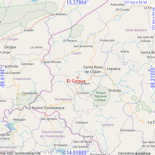
| Upper-left | 15.37904°, | -89.6198° |
| Center: | 14.7°, | -88.91667° |
| Lower-right: | 14.01885°, | -88.21355° |
| Map W x H: | 151.2×151.2 km | = 94×94mi |
| max Lat: | 16.45° ⇑62% North |
| El Corpus: | 14.7° |
| min Lat: | ⇓38% South 13.11667° |
| min Long | El Corpus | max Long |
| -89.23333° | -88.91667° | -83.23333° |
| W 5.2%⇐ | ⇒94.8% E |
Elevation
Elevation of El Corpus is 807 m = 2648 ft, and this is 245.8 m = 806 ft above average elevation for this country.
| Max E: |
1811 m = 5942 ft | 26.2% |
| El Corpus | 807 m 2648 ft | |
| Avg. | 561.2 m = 1841 ft | |
Min E: |
1 m = 3 ft | 73.8% |
See also: Honduras elevation on elevation.city.
Geographical zone
El Corpus is located in North Torrid zone (between Equator and Tropic of Cancer). Distance of this Northern Tropic circle is 971.4 km =603.6 mi to North.| Distance of | km | miles | from El Corpus |
|---|---|---|---|
| North Pole | 8372.6 | 5202.5 | to North |
| Arctic Circle | 5766.7 | 3583.3 | to North |
| Tropic Cancer | 971.4 | 603.6 | to North |
| Equator | 1634.5 | 1015.6 | to South |


Nearby cities:
15 places around El Corpus: (largest is in red/bold)
• Corquín
15.8 km =9.8 mi,  160°
160°
• Cucuyagua
7.7 km =4.8 mi,  135°
135°
• Dolores
20.6 km =12.8 mi,  25°
25°
• Dulce Nombre
18.9 km =11.7 mi, 28°
• El Derrumbo
15.4 km =9.6 mi,  68°
68°
• La Encarnación
18.3 km =11.4 mi,  258°
258°
• Los Arroyos
6.6 km =4.1 mi,  147°
147°
• Lucerna
16.8 km =10.4 mi,  186°
186°
• Ojos de Agua
10.8 km =6.7 mi,  90°
90°
• San Agustín
13.1 km =8.1 mi,  352°
352°
• San Antonio
21.1 km =13.1 mi, 194°
• San Francisco de Cones
20.5 km =12.7 mi,  174°
174°
• Santa Cruz
9.1 km =5.7 mi,  307°
307°
• Santa Rosa de Copán
16.5 km =10.3 mi,  63°
63°
• Yaruchel
21.4 km =13.3 mi, 149°
Sources, notices
• [Note1] Compared only with cities in Honduras existing in our database
• [Src1] Map data: © OpenStreetMap contributors (CC-BY-SA)
• [Src2] Other city data from geonames.org with taken over terms of usage.
• [Src3] Geographical zone / Annual Mean Temperature by Robert A. Rohde @ Wikipedia
