Vuka geodata
Vuka (Osječko-Baranjska) is a seat of a second-order administrative division; located in Croatia in Europe/Zagreb (GMT+2) time zone. With population of 1,064 people, there are 426 cities with bigger population in this country. Compared to other cities in Croatia, 50.4% of cities are located further ↓South; 90.3% of cities are located further ←West and 74.8% of cities have higher elevation than Vuka. Note1


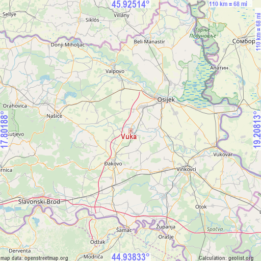
Vuka GPS coordinates[2]
45° 26' 2.004" North, 18° 30' 18" East
| Map corner | latitude | longitude |
|---|---|---|
| Upper-left | 45.92514°, | 17.80188° |
| Center: | 45.43389°, | 18.505° |
| Lower-right: | 44.93833°, | 19.20813° |
| Map W x H: | 109.7×109.7 km | = 68.2×68.2mi |
| max Lat: | 46.52694° ⇑49.6% North |
| Vuka: | 45.43389° |
| min Lat: | ⇓50.4% South 42.54972° |
| min Long | Vuka | max Long |
| 13.52389° | 18.505° | 19.37694° |
| W 90.3%⇐ | ⇒9.7% E |
Elevation
Elevation of Vuka is 89 m = 292 ft, and this is 64.3 m = 211 ft below average elevation for this country.
| Max E: |
827 m = 2713 ft | 74.8% |
| Avg. | 153.3 m = 503 ft | |
| Vuka | 89 m = 292 ft | |
Min E: |
-1 m = -3 ft | 25.2% |
See also: Croatia elevation on elevation.city.
Geographical zone
Vuka is located in North temperate zone (between Tropic of Cancer and the Arctic Circle). Distance of this North polar circle is 2349.4 km =1459.8 mi to North.| Distance of | km | miles | from Vuka |
|---|---|---|---|
| North Pole | 4955.3 | 3079.1 | to North |
| Arctic Circle | 2349.4 | 1459.8 | to North |
| Tropic Cancer | 2445.9 | 1519.8 | to South |
| Equator | 5051.8 | 3139 | to South |


Nearby cities:
15 places around Vuka: (largest is in red/bold)
• Beketinci
3.2 km =2 mi,  317°
317°
• Gorjani
11.1 km =6.9 mi,  249°
249°
• Ivanovci Gorjanski
10.1 km =6.3 mi,  224°
224°
• Josipovac Punitovački
6.9 km =4.3 mi,  260°
260°
• Kešinci
10.1 km =6.3 mi,  155°
155°
• Koritna
7.3 km =4.5 mi,  139°
139°
• Punitovci
6.9 km =4.3 mi,  269°
269°
• Semeljci
8.7 km =5.4 mi, 159°
• Tomašanci
8.5 km =5.3 mi,  231°
231°
• Viškovci
10.4 km =6.5 mi,  198°
198°
• Vladislavci
6.1 km =3.8 mi,  62°
62°
• Čepin
11 km =6.8 mi,  24°
24°
• Čepinski Martinci
9 km =5.6 mi,  341°
341°
• Široko Polje
4.1 km =2.5 mi, 218°
• Šodolovci
9.8 km =6.1 mi,  112°
112°
Sources, notices
• [Note1] Compared only with cities in Croatia existing in our database
• [Src1] Map data: © OpenStreetMap contributors (CC-BY-SA)
• [Src2] Other city data from geonames.org with taken over terms of usage.
• [Src3] Geographical zone / Annual Mean Temperature by Robert A. Rohde @ Wikipedia
