Kešinci geodata
Kešinci (Osječko-Baranjska) is a populated place; located in Croatia in Europe/Zagreb (GMT+2) time zone. With population of 834 people, there are 571 cities with bigger population in this country. Compared to other cities in Croatia, 55.7% of cities are located further ↑North; 91.1% of cities are located further ←West and 64.4% of cities have higher elevation than Kešinci. Note1


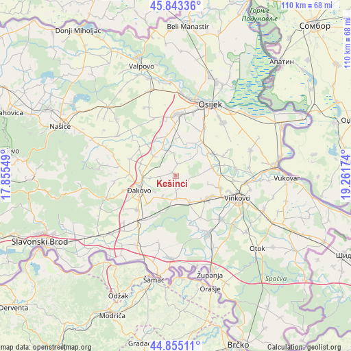
Kešinci GPS coordinates[2]
45° 21' 5.004" North, 18° 33' 30.996" East
| Map corner | latitude | longitude |
|---|---|---|
| Upper-left | 45.84336°, | 17.85549° |
| Center: | 45.35139°, | 18.55861° |
| Lower-right: | 44.85511°, | 19.26174° |
| Map W x H: | 109.9×109.9 km | = 68.3×68.3mi |
| max Lat: | 46.52694° ⇑55.7% North |
| Kešinci: | 45.35139° |
| min Lat: | ⇓44.3% South 42.54972° |
| min Long | Kešinci | max Long |
| 13.52389° | 18.55861° | 19.37694° |
| W 91.1%⇐ | ⇒8.9% E |
Elevation
Elevation of Kešinci is 103 m = 338 ft, and this is 50.3 m = 165 ft below average elevation for this country.
| Max E: |
827 m = 2713 ft | 64.4% |
| Avg. | 153.3 m = 503 ft | |
| Kešinci | 103 m = 338 ft | |
Min E: |
-1 m = -3 ft | 35.6% |
See also: Croatia elevation on elevation.city.
Geographical zone
Kešinci is located in North temperate zone (between Tropic of Cancer and the Arctic Circle). Distance of this North polar circle is 2358.6 km =1465.6 mi to North.| Distance of | km | miles | from Kešinci |
|---|---|---|---|
| North Pole | 4964.5 | 3084.8 | to North |
| Arctic Circle | 2358.6 | 1465.6 | to North |
| Tropic Cancer | 2436.7 | 1514.1 | to South |
| Equator | 5042.6 | 3133.3 | to South |


Nearby cities:
15 places around Kešinci: (largest is in red/bold)
• Ivanovci Gorjanski
11.5 km =7.1 mi,  280°
280°
• Koritna
3.7 km =2.3 mi,  8°
8°
• Kuševac
10.1 km =6.3 mi,  267°
267°
• Markušica
11.8 km =7.3 mi,  77°
77°
• Mrzović
3.9 km =2.4 mi,  136°
136°
• Novi Mikanovci
7.6 km =4.7 mi,  160°
160°
• Semeljci
1.6 km =1 mi,  311°
311°
• Stari Mikanovci
7.9 km =4.9 mi,  189°
189°
• Tomašanci
11.5 km =7.1 mi,  289°
289°
• Viškovci
7.6 km =4.7 mi,  264°
264°
• Vođinci
9.3 km =5.8 mi,  154°
154°
• Vrbica
5 km =3.1 mi,  180°
180°
• Vuka
10.1 km =6.3 mi,  335°
335°
• Široko Polje
9 km =5.6 mi, 311°
• Šodolovci
7.2 km =4.5 mi,  41°
41°
Sources, notices
• [Note1] Compared only with cities in Croatia existing in our database
• [Src1] Map data: © OpenStreetMap contributors (CC-BY-SA)
• [Src2] Other city data from geonames.org with taken over terms of usage.
• [Src3] Geographical zone / Annual Mean Temperature by Robert A. Rohde @ Wikipedia
