Čepin geodata
Čepin (Osječko-Baranjska) is a seat of a second-order administrative division; located in Croatia in Europe/Zagreb (GMT+2) time zone. With population of 9,548 people, there are 43 cities with bigger population in this country. Compared to other cities in Croatia, 55% of cities are located further ↓South; 91.2% of cities are located further ←West and 76.5% of cities have higher elevation than Čepin. Note1


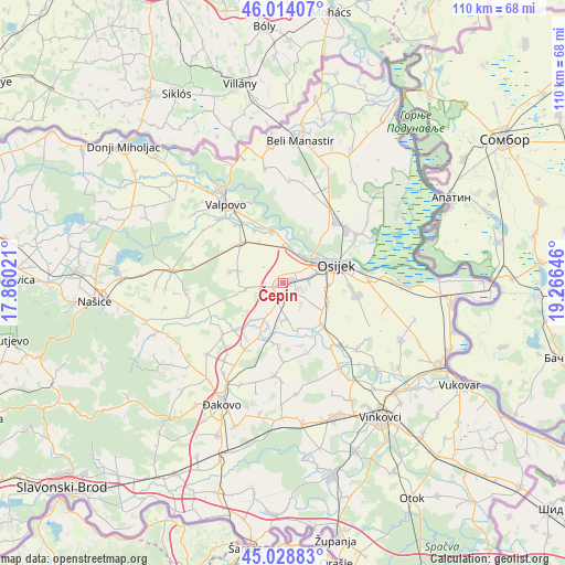
Čepin GPS coordinates[2]
45° 31' 24.996" North, 18° 33' 47.988" East
| Map corner | latitude | longitude |
|---|---|---|
| Upper-left | 46.01407°, | 17.86021° |
| Center: | 45.52361°, | 18.56333° |
| Lower-right: | 45.02883°, | 19.26646° |
| Map W x H: | 109.5×109.5 km | = 68×68mi |
| max Lat: | 46.52694° ⇑45% North |
| Čepin: | 45.52361° |
| min Lat: | ⇓55% South 42.54972° |
| min Long | Čepin | max Long |
| 13.52389° | 18.56333° | 19.37694° |
| W 91.2%⇐ | ⇒8.8% E |
Elevation
Elevation of Čepin is 88 m = 289 ft, and this is 65.3 m = 214 ft below average elevation for this country.
| Max E: |
827 m = 2713 ft | 76.5% |
| Avg. | 153.3 m = 503 ft | |
| Čepin | 88 m = 289 ft | |
Min E: |
-1 m = -3 ft | 23.5% |
See also: Croatia elevation on elevation.city.
Geographical zone
Čepin is located in North temperate zone (between Tropic of Cancer and the Arctic Circle). Distance of this North polar circle is 2339.4 km =1453.6 mi to North.| Distance of | km | miles | from Čepin |
|---|---|---|---|
| North Pole | 4945.3 | 3072.9 | to North |
| Arctic Circle | 2339.4 | 1453.6 | to North |
| Tropic Cancer | 2455.8 | 1526 | to South |
| Equator | 5061.8 | 3145.3 | to South |


Nearby cities:
15 places around Čepin: (largest is in red/bold)
• Antunovac
9.4 km =5.8 mi,  112°
112°
• Beketinci
10.1 km =6.3 mi,  221°
221°
• Brijest
8.5 km =5.3 mi,  92°
92°
• Brođanci
9.2 km =5.7 mi,  284°
284°
• Ernestinovo
10.9 km =6.8 mi,  136°
136°
• Josipovac
6.7 km =4.2 mi,  12°
12°
• Livana
3 km =1.9 mi,  79°
79°
• Osijek
10.6 km =6.6 mi,  73°
73°
• Petrijevci
10.2 km =6.3 mi,  347°
347°
• Samatovci
9.3 km =5.8 mi,  330°
330°
• Tvrđavica
10.2 km =6.3 mi,  58°
58°
• Višnjevac
6.4 km =4 mi,  38°
38°
• Vladislavci
7.2 km =4.5 mi,  173°
173°
• Vuka
11 km =6.8 mi,  204°
204°
• Čepinski Martinci
7.5 km =4.7 mi,  259°
259°
Sources, notices
• [Note1] Compared only with cities in Croatia existing in our database
• [Src1] Map data: © OpenStreetMap contributors (CC-BY-SA)
• [Src2] Other city data from geonames.org with taken over terms of usage.
• [Src3] Geographical zone / Annual Mean Temperature by Robert A. Rohde @ Wikipedia
