Tugare geodata
Tugare (Split-Dalmatia) is a populated place; located in Croatia in Europe/Zagreb (GMT+2) time zone. With population of 885 people, there are 537 cities with bigger population in this country. Compared to other cities in Croatia, 92.4% of cities are located further ↑North; 58.8% of cities are located further ←West and 93.1% of cities have lower elevation than Tugare. Note1


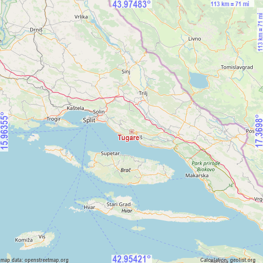
Tugare GPS coordinates[2]
43° 28' 0.012" North, 16° 40' 0.012" East
| Map corner | latitude | longitude |
|---|---|---|
| Upper-left | 43.97483°, | 15.96355° |
| Center: | 43.46667°, | 16.66667° |
| Lower-right: | 42.95421°, | 17.3698° |
| Map W x H: | 113.5×113.5 km | = 70.5×70.5mi |
| max Lat: | 46.52694° ⇑92.4% North |
| Tugare: | 43.46667° |
| min Lat: | ⇓7.6% South 42.54972° |
| min Long | Tugare | max Long |
| 13.52389° | 16.66667° | 19.37694° |
| W 58.8%⇐ | ⇒41.2% E |
Elevation
Elevation of Tugare is 346 m = 1135 ft, and this is 192.7 m = 632 ft above average elevation for this country.
| Max E: |
827 m = 2713 ft | 6.9% |
| Tugare | 346 m 1135 ft | |
| Avg. | 153.3 m = 503 ft | |
Min E: |
-1 m = -3 ft | 93.1% |
See also: Croatia elevation on elevation.city.
Geographical zone
Tugare is located in North temperate zone (between Tropic of Cancer and the Arctic Circle). Distance of this Northern Tropic circle is 2227.1 km =1383.9 mi to South.| Distance of | km | miles | from Tugare |
|---|---|---|---|
| North Pole | 5174 | 3215 | to North |
| Arctic Circle | 2568.1 | 1595.7 | to North |
| Tropic Cancer | 2227.1 | 1383.9 | to South |
| Equator | 4833 | 3003.1 | to South |


Nearby cities:
15 places around Tugare: (largest is in red/bold)
• Dugi Rat
3.2 km =2 mi,  223°
223°
• Duće
2.7 km =1.7 mi,  177°
177°
• Gata
2.7 km =1.7 mi,  90°
90°
• Jesenice
5.3 km =3.3 mi,  263°
263°
• Kamen
13.3 km =8.3 mi,  293°
293°
• Kučine
13.2 km =8.2 mi,  303°
303°
• Kučiće
11.4 km =7.1 mi,  109°
109°
• Omiš
3 km =1.9 mi,  144°
144°
• Podstrana
9.7 km =6 mi,  283°
283°
• Postira
10.5 km =6.5 mi,  195°
195°
• Srinjine
5.7 km =3.5 mi, 289°
• Stanići
7.7 km =4.8 mi, 139°
• Stobreč
12.3 km =7.6 mi, 288°
• Supetar
13.1 km =8.1 mi,  225°
225°
• Žrnovnica
10.6 km =6.6 mi, 304°
Sources, notices
• [Note1] Compared only with cities in Croatia existing in our database
• [Src1] Map data: © OpenStreetMap contributors (CC-BY-SA)
• [Src2] Other city data from geonames.org with taken over terms of usage.
• [Src3] Geographical zone / Annual Mean Temperature by Robert A. Rohde @ Wikipedia
