Omiš geodata
Omiš (Split-Dalmatia) is a seat of a second-order administrative division; located in Croatia in Europe/Zagreb (GMT+2) time zone. With population of 6,597 people, there are 60 cities with bigger population in this country. Compared to other cities in Croatia, 93.2% of cities are located further ↑North; 59.7% of cities are located further ←West and 99.8% of cities have higher elevation than Omiš. Note1


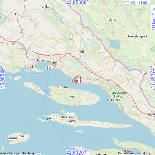
Omiš GPS coordinates[2]
43° 26' 40.992" North, 16° 41' 18.996" East
| Map corner | latitude | longitude |
|---|---|---|
| Upper-left | 43.95306°, | 15.98549° |
| Center: | 43.44472°, | 16.68861° |
| Lower-right: | 42.93207°, | 17.39174° |
| Map W x H: | 113.5×113.5 km | = 70.5×70.5mi |
| max Lat: | 46.52694° ⇑93.2% North |
| Omiš: | 43.44472° |
| min Lat: | ⇓6.8% South 42.54972° |
| min Long | Omiš | max Long |
| 13.52389° | 16.68861° | 19.37694° |
| W 59.7%⇐ | ⇒40.3% E |
Elevation
Elevation of Omiš is 0 m = 0 ft, and this is 153.3 m = 503 ft below average elevation for this country.
| Max E: |
827 m = 2713 ft | 99.8% |
| Avg. | 153.3 m = 503 ft | |
| Omiš | 0 m = 0 ft | |
Min E: |
-1 m = -3 ft | 0.2% |
See also: Croatia elevation on elevation.city.
Geographical zone
Omiš is located in North temperate zone (between Tropic of Cancer and the Arctic Circle). Distance of this Northern Tropic circle is 2224.7 km =1382.4 mi to South.| Distance of | km | miles | from Omiš |
|---|---|---|---|
| North Pole | 5176.5 | 3216.5 | to North |
| Arctic Circle | 2570.6 | 1597.3 | to North |
| Tropic Cancer | 2224.7 | 1382.4 | to South |
| Equator | 4830.6 | 3001.6 | to South |


Nearby cities:
15 places around Omiš: (largest is in red/bold)
• Dugi Rat
3.9 km =2.4 mi,  272°
272°
• Duće
1.7 km =1.1 mi,  262°
262°
• Gata
2.6 km =1.6 mi,  20°
20°
• Jesenice
7.2 km =4.5 mi,  285°
285°
• Kostanje
11.7 km =7.3 mi,  92°
92°
• Kučiće
9.1 km =5.7 mi,  98°
98°
• Podstrana
12.1 km =7.5 mi, 292°
• Postira
9 km =5.6 mi,  211°
211°
• Pučišća
11.4 km =7.1 mi,  161°
161°
• Srinjine
8.3 km =5.2 mi,  300°
300°
• Stanići
4.7 km =2.9 mi,  136°
136°
• Stobreč
14.9 km =9.3 mi, 295°
• Supetar
13 km =8.1 mi,  238°
238°
• Tugare
3 km =1.9 mi,  324°
324°
• Žrnovnica
13.5 km =8.4 mi,  309°
309°
Sources, notices
• [Note1] Compared only with cities in Croatia existing in our database
• [Src1] Map data: © OpenStreetMap contributors (CC-BY-SA)
• [Src2] Other city data from geonames.org with taken over terms of usage.
• [Src3] Geographical zone / Annual Mean Temperature by Robert A. Rohde @ Wikipedia
