Trnjani geodata
Trnjani (Slavonski Brod-Posavina) is a populated place; located in Croatia in Europe/Zagreb (GMT+2) time zone. With population of 786 people, there are 611 cities with bigger population in this country. Compared to other cities in Croatia, 68% of cities are located further ↑North; 83.7% of cities are located further ←West and 66.9% of cities have higher elevation than Trnjani. Note1


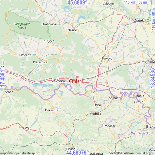
Trnjani GPS coordinates[2]
45° 11' 15" North, 18° 8' 31.992" East
| Map corner | latitude | longitude |
|---|---|---|
| Upper-left | 45.6809°, | 17.4391° |
| Center: | 45.1875°, | 18.14222° |
| Lower-right: | 44.68979°, | 18.84535° |
| Map W x H: | 110.2×110.2 km | = 68.5×68.5mi |
| max Lat: | 46.52694° ⇑68% North |
| Trnjani: | 45.1875° |
| min Lat: | ⇓32% South 42.54972° |
| min Long | Trnjani | max Long |
| 13.52389° | 18.14222° | 19.37694° |
| W 83.7%⇐ | ⇒16.3% E |
Elevation
Elevation of Trnjani is 100 m = 328 ft, and this is 53.3 m = 175 ft below average elevation for this country.
| Max E: |
827 m = 2713 ft | 66.9% |
| Avg. | 153.3 m = 503 ft | |
| Trnjani | 100 m = 328 ft | |
Min E: |
-1 m = -3 ft | 33.1% |
See also: Croatia elevation on elevation.city.
Geographical zone
Trnjani is located in North temperate zone (between Tropic of Cancer and the Arctic Circle). Distance of this North polar circle is 2376.8 km =1476.9 mi to North.| Distance of | km | miles | from Trnjani |
|---|---|---|---|
| North Pole | 4982.7 | 3096.1 | to North |
| Arctic Circle | 2376.8 | 1476.9 | to North |
| Tropic Cancer | 2418.5 | 1502.8 | to South |
| Equator | 5024.4 | 3122 | to South |


Nearby cities:
15 places around Trnjani: (largest is in red/bold)
• Bicko Selo
4.5 km =2.8 mi,  120°
120°
• Bukovlje
5.7 km =3.5 mi,  267°
267°
• Donja Vrba
3.7 km =2.3 mi,  229°
229°
• Garčin
3.2 km =2 mi,  99°
99°
• Gornja Vrba
7 km =4.3 mi,  239°
239°
• Klakar
9.9 km =6.2 mi,  184°
184°
• Klokočevik
3.6 km =2.2 mi,  9°
9°
• Korenica
4.5 km =2.8 mi,  23°
23°
• Oprisavci
8 km =5 mi, 120°
• Podvinje
9 km =5.6 mi, 271°
• Ruščica
6.7 km =4.2 mi, 227°
• Sapci
5.1 km =3.2 mi, 100°
• Staro Topolje
8.3 km =5.2 mi,  88°
88°
• Vranovci
4.1 km =2.5 mi,  264°
264°
• Zadubravlje
2.8 km =1.7 mi,  160°
160°
Sources, notices
• [Note1] Compared only with cities in Croatia existing in our database
• [Src1] Map data: © OpenStreetMap contributors (CC-BY-SA)
• [Src2] Other city data from geonames.org with taken over terms of usage.
• [Src3] Geographical zone / Annual Mean Temperature by Robert A. Rohde @ Wikipedia
