Ruščica geodata
Ruščica (Slavonski Brod-Posavina) is a populated place; located in Croatia in Europe/Zagreb (GMT+2) time zone. With population of 1,135 people, there are 400 cities with bigger population in this country. Compared to other cities in Croatia, 71.7% of cities are located further ↑North; 82.9% of cities are located further ←West and 74.8% of cities have higher elevation than Ruščica. Note1


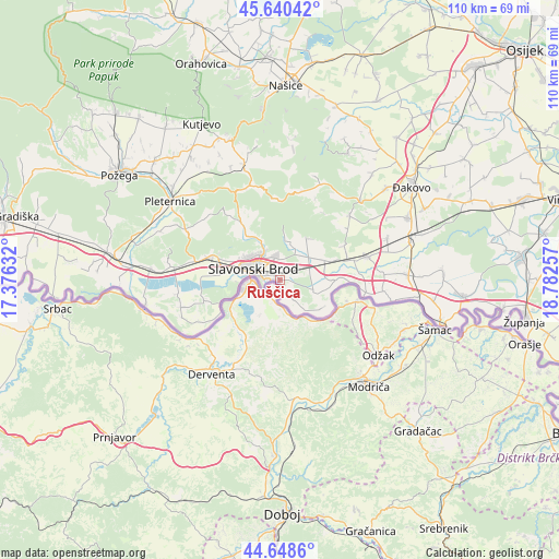
Ruščica GPS coordinates[2]
45° 8' 48.012" North, 18° 4' 45.984" East
| Map corner | latitude | longitude |
|---|---|---|
| Upper-left | 45.64042°, | 17.37632° |
| Center: | 45.14667°, | 18.07944° |
| Lower-right: | 44.6486°, | 18.78257° |
| Map W x H: | 110.3×110.3 km | = 68.5×68.5mi |
| max Lat: | 46.52694° ⇑71.7% North |
| Ruščica: | 45.14667° |
| min Lat: | ⇓28.3% South 42.54972° |
| min Long | Ruščica | max Long |
| 13.52389° | 18.07944° | 19.37694° |
| W 82.9%⇐ | ⇒17.1% E |
Elevation
Elevation of Ruščica is 89 m = 292 ft, and this is 64.3 m = 211 ft below average elevation for this country.
| Max E: |
827 m = 2713 ft | 74.8% |
| Avg. | 153.3 m = 503 ft | |
| Ruščica | 89 m = 292 ft | |
Min E: |
-1 m = -3 ft | 25.2% |
See also: Croatia elevation on elevation.city.
Geographical zone
Ruščica is located in North temperate zone (between Tropic of Cancer and the Arctic Circle). Distance of this North polar circle is 2381.3 km =1479.7 mi to North.| Distance of | km | miles | from Ruščica |
|---|---|---|---|
| North Pole | 4987.2 | 3098.9 | to North |
| Arctic Circle | 2381.3 | 1479.7 | to North |
| Tropic Cancer | 2413.9 | 1499.9 | to South |
| Equator | 5019.8 | 3119.2 | to South |


Nearby cities:
15 places around Ruščica: (largest is in red/bold)
• Bicko Selo
9.1 km =5.7 mi,  75°
75°
• Brodski Varoš
8.8 km =5.5 mi,  295°
295°
• Bukovlje
4.4 km =2.7 mi,  350°
350°
• Donja Vrba
3 km =1.9 mi,  45°
45°
• Garčin
9.1 km =5.7 mi,  63°
63°
• Gornja Vrba
1.4 km =0.9 mi,  311°
311°
• Gromačnik
10.2 km =6.3 mi,  290°
290°
• Klakar
6.8 km =4.2 mi,  142°
142°
• Klokočevik
9.8 km =6.1 mi,  34°
34°
• Podcrkavlje
10.2 km =6.3 mi,  327°
327°
• Podvinje
6.4 km =4 mi,  319°
319°
• Slavonski Brod
5.2 km =3.2 mi, 286°
• Trnjani
6.7 km =4.2 mi, 47°
• Vranovci
4.3 km =2.7 mi,  11°
11°
• Zadubravlje
6.2 km =3.9 mi,  72°
72°
Sources, notices
• [Note1] Compared only with cities in Croatia existing in our database
• [Src1] Map data: © OpenStreetMap contributors (CC-BY-SA)
• [Src2] Other city data from geonames.org with taken over terms of usage.
• [Src3] Geographical zone / Annual Mean Temperature by Robert A. Rohde @ Wikipedia
