Tounj geodata
Tounj (Karlovačka) is a seat of a second-order administrative division; located in Croatia in Europe/Zagreb (GMT+2) time zone. In our database, there are 904 cities with bigger population. Compared to other cities in Croatia, 63.2% of cities are located further ↑North; 85.6% of cities are located further →East and 86.1% of cities have lower elevation than Tounj. Note1


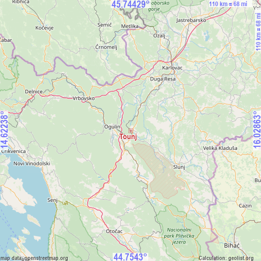
Tounj GPS coordinates[2]
45° 15' 5.22" North, 15° 19' 31.8" East
| Map corner | latitude | longitude |
|---|---|---|
| Upper-left | 45.74429°, | 14.62238° |
| Center: | 45.25145°, | 15.3255° |
| Lower-right: | 44.7543°, | 16.02863° |
| Map W x H: | 110.1×110.1 km | = 68.4×68.4mi |
| max Lat: | 46.52694° ⇑63.2% North |
| Tounj: | 45.25145° |
| min Lat: | ⇓36.8% South 42.54972° |
| min Long | Tounj | max Long |
| 13.52389° | 15.3255° | 19.37694° |
| W 14.4%⇐ | ⇒85.6% E |
Elevation
Elevation of Tounj is 246 m = 807 ft, and this is 92.7 m = 304 ft above average elevation for this country.
| Max E: |
827 m = 2713 ft | 13.9% |
| Tounj | 246 m 807 ft | |
| Avg. | 153.3 m = 503 ft | |
Min E: |
-1 m = -3 ft | 86.1% |
See also: Croatia elevation on elevation.city.
Geographical zone
Tounj is located in North temperate zone (between Tropic of Cancer and the Arctic Circle). Distance of this North polar circle is 2369.7 km =1472.5 mi to North.| Distance of | km | miles | from Tounj |
|---|---|---|---|
| North Pole | 4975.6 | 3091.7 | to North |
| Arctic Circle | 2369.7 | 1472.5 | to North |
| Tropic Cancer | 2425.6 | 1507.2 | to South |
| Equator | 5031.5 | 3126.4 | to South |


Nearby cities:
15 places around Tounj: (largest is in red/bold)
• Barilović
22.9 km =14.2 mi,  50°
50°
• Bosiljevo
16.9 km =10.5 mi,  350°
350°
• Duga Resa
23.5 km =14.6 mi,  32°
32°
• Generalski Stol
11.6 km =7.2 mi,  22°
22°
• Hreljin Ogulinski
12.3 km =7.6 mi,  294°
294°
• Josipdol
8 km =5 mi,  202°
202°
• Križpolje
28.5 km =17.7 mi,  206°
206°
• Krnjak
23.3 km =14.5 mi,  67°
67°
• Ogulin
7.8 km =4.8 mi,  282°
282°
• Oštarije
5.1 km =3.2 mi,  233°
233°
• Plaški
19.7 km =12.2 mi,  170°
170°
• Slunj
25.3 km =15.7 mi,  126°
126°
• Sveti Petar
10.4 km =6.5 mi, 289°
• Tušilović
27.9 km =17.3 mi, 54°
• Vrbovsko
23.3 km =14.5 mi,  303°
303°
Sources, notices
• [Note1] Compared only with cities in Croatia existing in our database
• [Src1] Map data: © OpenStreetMap contributors (CC-BY-SA)
• [Src2] Other city data from geonames.org with taken over terms of usage.
• [Src3] Geographical zone / Annual Mean Temperature by Robert A. Rohde @ Wikipedia
