Strahoninec geodata
Strahoninec (Međimurska) is a seat of a second-order administrative division; located in Croatia in Europe/Zagreb (GMT+2) time zone. With population of 2,741 people, there are 156 cities with bigger population in this country. Compared to other cities in Croatia, 96.4% of cities are located further ↓South; 52.2% of cities are located further →East and 69.7% of cities have lower elevation than Strahoninec. Note1


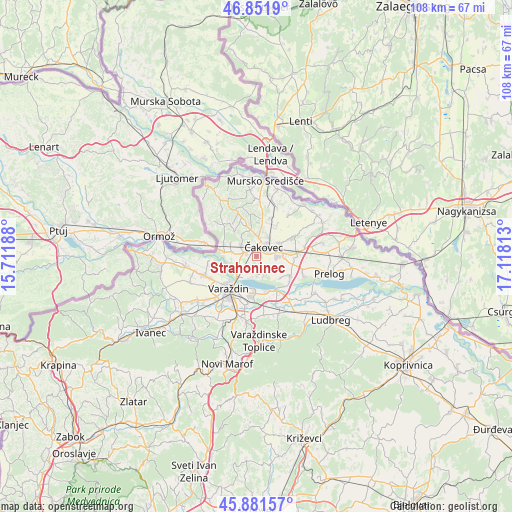
Strahoninec GPS coordinates[2]
46° 22' 8.004" North, 16° 24' 54" East
| Map corner | latitude | longitude |
|---|---|---|
| Upper-left | 46.8519°, | 15.71188° |
| Center: | 46.36889°, | 16.415° |
| Lower-right: | 45.88157°, | 17.11813° |
| Map W x H: | 107.9×107.9 km | = 67×67mi |
| max Lat: | 46.52694° ⇑3.6% North |
| Strahoninec: | 46.36889° |
| min Lat: | ⇓96.4% South 42.54972° |
| min Long | Strahoninec | max Long |
| 13.52389° | 16.415° | 19.37694° |
| W 47.8%⇐ | ⇒52.2% E |
Elevation
Elevation of Strahoninec is 166 m = 545 ft, and this is 12.7 m = 42 ft above average elevation for this country.
| Max E: |
827 m = 2713 ft | 30.3% |
| Strahoninec | 166 m 545 ft | |
| Avg. | 153.3 m = 503 ft | |
Min E: |
-1 m = -3 ft | 69.7% |
See also: Croatia elevation on elevation.city.
Geographical zone
Strahoninec is located in North temperate zone (between Tropic of Cancer and the Arctic Circle). Distance of this North polar circle is 2245.4 km =1395.2 mi to North.| Distance of | km | miles | from Strahoninec |
|---|---|---|---|
| North Pole | 4851.3 | 3014.5 | to North |
| Arctic Circle | 2245.4 | 1395.2 | to North |
| Tropic Cancer | 2549.8 | 1584.4 | to South |
| Equator | 5155.7 | 3203.6 | to South |


Nearby cities:
15 places around Strahoninec: (largest is in red/bold)
• Brezje
5.9 km =3.7 mi,  340°
340°
• Dunjkovec
3.9 km =2.4 mi,  306°
306°
• Gornji Hrašćan
5.2 km =3.2 mi,  281°
281°
• Ivanovec
4.7 km =2.9 mi,  90°
90°
• Kuršanec
4.4 km =2.7 mi,  193°
193°
• Mačkovec
6.3 km =3.9 mi,  13°
13°
• Mihovljan
5.1 km =3.2 mi,  29°
29°
• Nedelišće
2.2 km =1.4 mi,  290°
290°
• Novo Selo na Dravi
4.4 km =2.7 mi,  162°
162°
• Pribislavec
5.8 km =3.6 mi,  63°
63°
• Slakovec
5 km =3.1 mi,  324°
324°
• Totovec
3.8 km =2.4 mi,  146°
146°
• Čakovec
2.3 km =1.4 mi,  39°
39°
• Šenkovec
4.5 km =2.8 mi, 6°
• Štefanec
6.2 km =3.9 mi, 90°
Sources, notices
• [Note1] Compared only with cities in Croatia existing in our database
• [Src1] Map data: © OpenStreetMap contributors (CC-BY-SA)
• [Src2] Other city data from geonames.org with taken over terms of usage.
• [Src3] Geographical zone / Annual Mean Temperature by Robert A. Rohde @ Wikipedia
