Šiškovci geodata
Šiškovci (Vukovar-Sirmium) is a populated place; located in Croatia in Europe/Zagreb (GMT+2) time zone. With population of 804 people, there are 598 cities with bigger population in this country. Compared to other cities in Croatia, 66.8% of cities are located further ↑North; 92.6% of cities are located further ←West and 83% of cities have higher elevation than Šiškovci. Note1


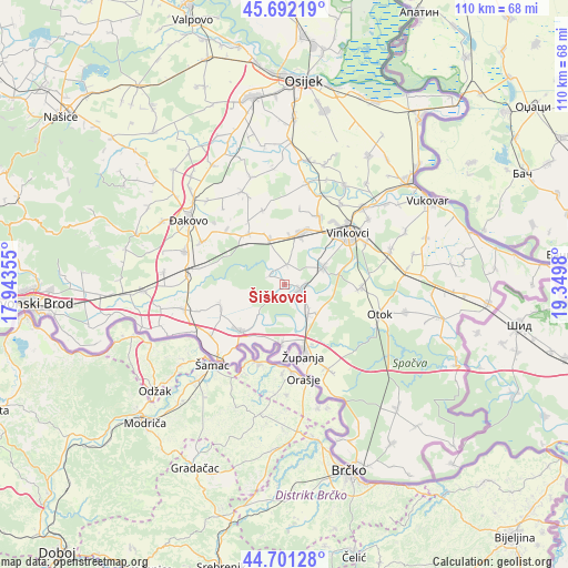
Šiškovci GPS coordinates[2]
45° 11' 56.004" North, 18° 38' 48.012" East
| Map corner | latitude | longitude |
|---|---|---|
| Upper-left | 45.69219°, | 17.94355° |
| Center: | 45.19889°, | 18.64667° |
| Lower-right: | 44.70128°, | 19.3498° |
| Map W x H: | 110.2×110.2 km | = 68.5×68.5mi |
| max Lat: | 46.52694° ⇑66.8% North |
| Šiškovci: | 45.19889° |
| min Lat: | ⇓33.2% South 42.54972° |
| min Long | Šiškovci | max Long |
| 13.52389° | 18.64667° | 19.37694° |
| W 92.6%⇐ | ⇒7.4% E |
Elevation
Elevation of Šiškovci is 82 m = 269 ft, and this is 71.3 m = 234 ft below average elevation for this country.
| Max E: |
827 m = 2713 ft | 83% |
| Avg. | 153.3 m = 503 ft | |
| Šiškovci | 82 m = 269 ft | |
Min E: |
-1 m = -3 ft | 17% |
See also: Croatia elevation on elevation.city.
Geographical zone
Šiškovci is located in North temperate zone (between Tropic of Cancer and the Arctic Circle). Distance of this North polar circle is 2375.5 km =1476.1 mi to North.| Distance of | km | miles | from Šiškovci |
|---|---|---|---|
| North Pole | 4981.4 | 3095.3 | to North |
| Arctic Circle | 2375.5 | 1476.1 | to North |
| Tropic Cancer | 2419.7 | 1503.5 | to South |
| Equator | 5025.6 | 3122.8 | to South |


Nearby cities:
15 places around Šiškovci: (largest is in red/bold)
• Andrijaševci
7.7 km =4.8 mi,  68°
68°
• Babina Greda
12.5 km =7.8 mi,  223°
223°
• Cerna
3.8 km =2.4 mi,  119°
119°
• Gradište
7.4 km =4.6 mi,  140°
140°
• Gundinci
13 km =8.1 mi,  249°
249°
• Ivankovo
10.4 km =6.5 mi,  16°
16°
• Novi Mikanovci
10.7 km =6.6 mi,  336°
336°
• Prkovci
3.3 km =2.1 mi,  301°
301°
• Retkovci
3.9 km =2.4 mi,  7°
7°
• Rokovci
8.4 km =5.2 mi,  64°
64°
• Stari Mikanovci
12.3 km =7.6 mi,  318°
318°
• Vođinci
9 km =5.6 mi, 341°
• Vrbica
13.8 km =8.6 mi,  329°
329°
• Štitar
11.5 km =7.1 mi,  182°
182°
• Županja
14.1 km =8.8 mi,  163°
163°
Sources, notices
• [Note1] Compared only with cities in Croatia existing in our database
• [Src1] Map data: © OpenStreetMap contributors (CC-BY-SA)
• [Src2] Other city data from geonames.org with taken over terms of usage.
• [Src3] Geographical zone / Annual Mean Temperature by Robert A. Rohde @ Wikipedia
