Županja geodata
Županja (Vukovar-Sirmium) is a seat of a second-order administrative division; located in Croatia in Europe/Zagreb (GMT+2) time zone. With population of 13,842 people, there are 30 cities with bigger population in this country. Compared to other cities in Croatia, 73.9% of cities are located further ↑North; 94% of cities are located further ←West and 83.8% of cities have higher elevation than Županja. Note1


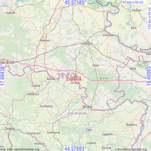
Županja GPS coordinates[2]
45° 4' 39" North, 18° 41' 51" East
| Map corner | latitude | longitude |
|---|---|---|
| Upper-left | 45.57185°, | 17.99438° |
| Center: | 45.0775°, | 18.6975° |
| Lower-right: | 44.57883°, | 19.40063° |
| Map W x H: | 110.4×110.4 km | = 68.6×68.6mi |
| max Lat: | 46.52694° ⇑73.9% North |
| Županja: | 45.0775° |
| min Lat: | ⇓26.1% South 42.54972° |
| min Long | Županja | max Long |
| 13.52389° | 18.6975° | 19.37694° |
| W 94%⇐ | ⇒6% E |
Elevation
Elevation of Županja is 81 m = 266 ft, and this is 72.3 m = 237 ft below average elevation for this country.
| Max E: |
827 m = 2713 ft | 83.8% |
| Avg. | 153.3 m = 503 ft | |
| Županja | 81 m = 266 ft | |
Min E: |
-1 m = -3 ft | 16.2% |
See also: Croatia elevation on elevation.city.
Geographical zone
Županja is located in North temperate zone (between Tropic of Cancer and the Arctic Circle). Distance of this North polar circle is 2389 km =1484.5 mi to North.| Distance of | km | miles | from Županja |
|---|---|---|---|
| North Pole | 4994.9 | 3103.7 | to North |
| Arctic Circle | 2389 | 1484.5 | to North |
| Tropic Cancer | 2406.2 | 1495.1 | to South |
| Equator | 5012.1 | 3114.4 | to South |


Nearby cities:
15 places around Županja: (largest is in red/bold)
• Andrijaševci
16.7 km =10.4 mi,  10°
10°
• Babina Greda
13.4 km =8.3 mi,  289°
289°
• Bošnjaci
5.5 km =3.4 mi,  123°
123°
• Cerna
11.6 km =7.2 mi,  356°
356°
• Gradište
7.9 km =4.9 mi, 5°
• Kruševica
16.9 km =10.5 mi,  270°
270°
• Otok
16.5 km =10.3 mi,  62°
62°
• Privlaka
17 km =10.6 mi,  40°
40°
• Prkovci
16.7 km =10.4 mi,  335°
335°
• Rajevo Selo
18.2 km =11.3 mi,  159°
159°
• Retkovci
17.7 km =11 mi,  348°
348°
• Rokovci
17.5 km =10.9 mi, 12°
• Slavonski Šamac
16.4 km =10.2 mi, 265°
• Šiškovci
14.1 km =8.8 mi, 343°
• Štitar
4.9 km =3 mi, 294°
Sources, notices
• [Note1] Compared only with cities in Croatia existing in our database
• [Src1] Map data: © OpenStreetMap contributors (CC-BY-SA)
• [Src2] Other city data from geonames.org with taken over terms of usage.
• [Src3] Geographical zone / Annual Mean Temperature by Robert A. Rohde @ Wikipedia
