Štitar geodata
Štitar (Vukovar-Sirmium) is a seat of a second-order administrative division; located in Croatia in Europe/Zagreb (GMT+2) time zone. With population of 2,621 people, there are 166 cities with bigger population in this country. Compared to other cities in Croatia, 73.3% of cities are located further ↑North; 92.4% of cities are located further ←West and 83% of cities have higher elevation than Štitar. Note1


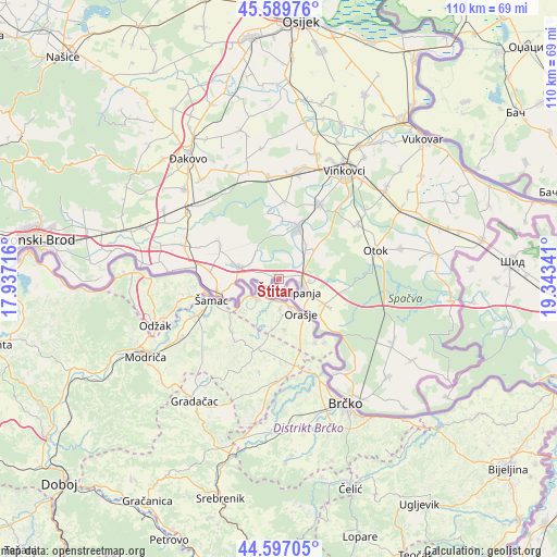
Štitar GPS coordinates[2]
45° 5' 44.016" North, 18° 38' 25.008" East
| Map corner | latitude | longitude |
|---|---|---|
| Upper-left | 45.58976°, | 17.93716° |
| Center: | 45.09556°, | 18.64028° |
| Lower-right: | 44.59705°, | 19.34341° |
| Map W x H: | 110.4×110.4 km | = 68.6×68.6mi |
| max Lat: | 46.52694° ⇑73.3% North |
| Štitar: | 45.09556° |
| min Lat: | ⇓26.7% South 42.54972° |
| min Long | Štitar | max Long |
| 13.52389° | 18.64028° | 19.37694° |
| W 92.4%⇐ | ⇒7.6% E |
Elevation
Elevation of Štitar is 82 m = 269 ft, and this is 71.3 m = 234 ft below average elevation for this country.
| Max E: |
827 m = 2713 ft | 83% |
| Avg. | 153.3 m = 503 ft | |
| Štitar | 82 m = 269 ft | |
Min E: |
-1 m = -3 ft | 17% |
See also: Croatia elevation on elevation.city.
Geographical zone
Štitar is located in North temperate zone (between Tropic of Cancer and the Arctic Circle). Distance of this North polar circle is 2387 km =1483.2 mi to North.| Distance of | km | miles | from Štitar |
|---|---|---|---|
| North Pole | 4992.9 | 3102.4 | to North |
| Arctic Circle | 2387 | 1483.2 | to North |
| Tropic Cancer | 2408.2 | 1496.4 | to South |
| Equator | 5014.2 | 3115.7 | to South |


Nearby cities:
15 places around Štitar: (largest is in red/bold)
• Andrijaševci
16.3 km =10.1 mi,  28°
28°
• Babina Greda
8.5 km =5.3 mi,  286°
286°
• Bošnjaci
10.4 km =6.5 mi,  119°
119°
• Cerna
10.3 km =6.4 mi,  21°
21°
• Gradište
7.8 km =4.8 mi,  41°
41°
• Gundinci
13.6 km =8.5 mi,  300°
300°
• Jaruge
17.4 km =10.8 mi,  277°
277°
• Kruševica
12.5 km =7.8 mi,  260°
260°
• Prkovci
13.4 km =8.3 mi,  350°
350°
• Retkovci
15.4 km =9.6 mi,  3°
3°
• Rokovci
17.1 km =10.6 mi, 28°
• Sikirevci
13.9 km =8.6 mi, 276°
• Slavonski Šamac
12.3 km =7.6 mi,  254°
254°
• Šiškovci
11.5 km =7.1 mi, 2°
• Županja
4.9 km =3 mi,  114°
114°
Sources, notices
• [Note1] Compared only with cities in Croatia existing in our database
• [Src1] Map data: © OpenStreetMap contributors (CC-BY-SA)
• [Src2] Other city data from geonames.org with taken over terms of usage.
• [Src3] Geographical zone / Annual Mean Temperature by Robert A. Rohde @ Wikipedia
