Sirač geodata
Sirač (Bjelovarsko-Bilogorska) is a seat of a second-order administrative division; located in Croatia in Europe/Zagreb (GMT+2) time zone. With population of 1,614 people, there are 271 cities with bigger population in this country. Compared to other cities in Croatia, 54.9% of cities are located further ↓South; 72.9% of cities are located further ←West and 69% of cities have lower elevation than Sirač. Note1


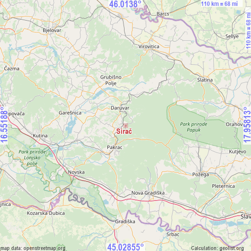
Sirač GPS coordinates[2]
45° 31' 23.988" North, 17° 15' 18" East
| Map corner | latitude | longitude |
|---|---|---|
| Upper-left | 46.0138°, | 16.55188° |
| Center: | 45.52333°, | 17.255° |
| Lower-right: | 45.02855°, | 17.95813° |
| Map W x H: | 109.5×109.5 km | = 68×68mi |
| max Lat: | 46.52694° ⇑45.1% North |
| Sirač: | 45.52333° |
| min Lat: | ⇓54.9% South 42.54972° |
| min Long | Sirač | max Long |
| 13.52389° | 17.255° | 19.37694° |
| W 72.9%⇐ | ⇒27.1% E |
Elevation
Elevation of Sirač is 165 m = 541 ft, and this is 11.7 m = 38 ft above average elevation for this country.
| Max E: |
827 m = 2713 ft | 31% |
| Sirač | 165 m 541 ft | |
| Avg. | 153.3 m = 503 ft | |
Min E: |
-1 m = -3 ft | 69% |
See also: Croatia elevation on elevation.city.
Geographical zone
Sirač is located in North temperate zone (between Tropic of Cancer and the Arctic Circle). Distance of this North polar circle is 2339.5 km =1453.7 mi to North.| Distance of | km | miles | from Sirač |
|---|---|---|---|
| North Pole | 4945.3 | 3072.9 | to North |
| Arctic Circle | 2339.5 | 1453.7 | to North |
| Tropic Cancer | 2455.8 | 1526 | to South |
| Equator | 5061.7 | 3145.2 | to South |


Nearby cities:
15 places around Sirač: (largest is in red/bold)
• Badljevina
5 km =3.1 mi,  255°
255°
• Daruvar
7.8 km =4.8 mi,  342°
342°
• Dežanovac
14.1 km =8.8 mi,  291°
291°
• Doljani
5.4 km =3.4 mi,  334°
334°
• Garešnica
25.1 km =15.6 mi,  283°
283°
• Grubišno Polje
20.9 km =13 mi, 342°
• Hercegovac
24.1 km =15 mi,  308°
308°
• Končanica
14.3 km =8.9 mi, 331°
• Lipik
14.8 km =9.2 mi,  212°
212°
• Pakrac
11 km =6.8 mi, 208°
• Poljana
22.2 km =13.8 mi,  254°
254°
• Veliki Bastaji
14.7 km =9.1 mi,  22°
22°
• Veliki Zdenci
20.2 km =12.6 mi, 325°
• Voćin
25.1 km =15.6 mi,  65°
65°
• Ðulovac
21.1 km =13.1 mi,  41°
41°
Sources, notices
• [Note1] Compared only with cities in Croatia existing in our database
• [Src1] Map data: © OpenStreetMap contributors (CC-BY-SA)
• [Src2] Other city data from geonames.org with taken over terms of usage.
• [Src3] Geographical zone / Annual Mean Temperature by Robert A. Rohde @ Wikipedia
