Ðulovac geodata
Ðulovac (Bjelovarsko-Bilogorska) is a seat of a second-order administrative division; located in Croatia in Europe/Zagreb (GMT+2) time zone. In our database, there are 904 cities with bigger population. Compared to other cities in Croatia, 62.4% of cities are located further ↓South; 75.1% of cities are located further ←West and 85.7% of cities have lower elevation than Ðulovac. Note1


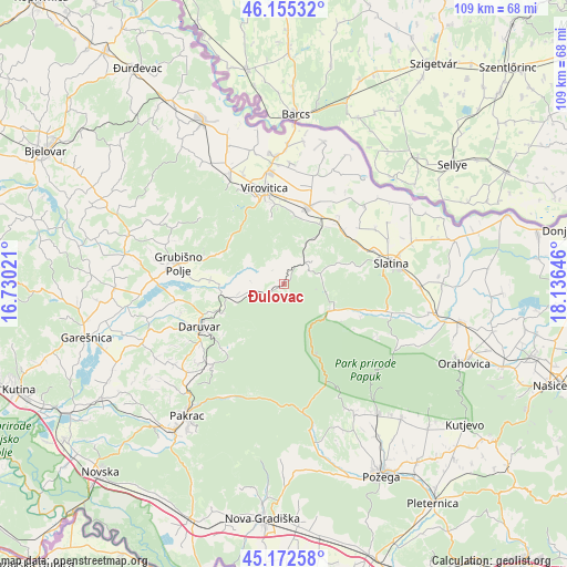
Ðulovac GPS coordinates[2]
45° 39' 57.996" North, 17° 25' 59.988" East
| Map corner | latitude | longitude |
|---|---|---|
| Upper-left | 46.15532°, | 16.73021° |
| Center: | 45.66611°, | 17.43333° |
| Lower-right: | 45.17258°, | 18.13646° |
| Map W x H: | 109.3×109.3 km | = 67.9×67.9mi |
| max Lat: | 46.52694° ⇑37.6% North |
| Ðulovac: | 45.66611° |
| min Lat: | ⇓62.4% South 42.54972° |
| min Long | Ðulovac | max Long |
| 13.52389° | 17.43333° | 19.37694° |
| W 75.1%⇐ | ⇒24.9% E |
Elevation
Elevation of Ðulovac is 244 m = 801 ft, and this is 90.7 m = 298 ft above average elevation for this country.
| Max E: |
827 m = 2713 ft | 14.3% |
| Ðulovac | 244 m 801 ft | |
| Avg. | 153.3 m = 503 ft | |
Min E: |
-1 m = -3 ft | 85.7% |
See also: Croatia elevation on elevation.city.
Geographical zone
Ðulovac is located in North temperate zone (between Tropic of Cancer and the Arctic Circle). Distance of this North polar circle is 2323.6 km =1443.8 mi to North.| Distance of | km | miles | from Ðulovac |
|---|---|---|---|
| North Pole | 4929.5 | 3063 | to North |
| Arctic Circle | 2323.6 | 1443.8 | to North |
| Tropic Cancer | 2471.7 | 1535.8 | to South |
| Equator | 5077.6 | 3155.1 | to South |


Nearby cities:
15 places around Ðulovac: (largest is in red/bold)
• Borova
13.5 km =8.4 mi,  9°
9°
• Cabuna
14.9 km =9.3 mi,  49°
49°
• Daruvar
18.2 km =11.3 mi,  242°
242°
• Doljani
19.5 km =12.1 mi, 235°
• Grubišno Polje
20.6 km =12.8 mi,  281°
281°
• Končanica
21 km =13 mi,  260°
260°
• Rezovac
13.1 km =8.1 mi,  354°
354°
• Sirač
21.1 km =13.1 mi,  221°
221°
• Sladojevci
18.6 km =11.6 mi,  69°
69°
• Slatina
21.3 km =13.2 mi,  78°
78°
• Suhopolje
15.7 km =9.8 mi,  18°
18°
• Veliki Bastaji
8.5 km =5.3 mi,  254°
254°
• Virovitica
18.8 km =11.7 mi, 348°
• Voćin
10.4 km =6.5 mi,  121°
121°
• Ćeralije
20.3 km =12.6 mi,  104°
104°
Sources, notices
• [Note1] Compared only with cities in Croatia existing in our database
• [Src1] Map data: © OpenStreetMap contributors (CC-BY-SA)
• [Src2] Other city data from geonames.org with taken over terms of usage.
• [Src3] Geographical zone / Annual Mean Temperature by Robert A. Rohde @ Wikipedia
