Rogotin geodata
Rogotin (Dubrovačko-Neretvanska) is a populated place; located in Croatia in Europe/Zagreb (GMT+2) time zone. With population of 665 people, there are 698 cities with bigger population in this country. Compared to other cities in Croatia, 96.8% of cities are located further ↑North; 75.7% of cities are located further ←West and 99% of cities have higher elevation than Rogotin. Note1


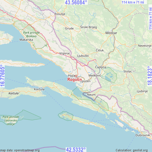
Rogotin GPS coordinates[2]
43° 2' 57.012" North, 17° 28' 45.012" East
| Map corner | latitude | longitude |
|---|---|---|
| Upper-left | 43.56084°, | 16.77605° |
| Center: | 43.04917°, | 17.47917° |
| Lower-right: | 42.5332°, | 18.1823° |
| Map W x H: | 114.3×114.3 km | = 71×71mi |
| max Lat: | 46.52694° ⇑96.8% North |
| Rogotin: | 43.04917° |
| min Lat: | ⇓3.2% South 42.54972° |
| min Long | Rogotin | max Long |
| 13.52389° | 17.47917° | 19.37694° |
| W 75.7%⇐ | ⇒24.3% E |
Elevation
Elevation of Rogotin is 2 m = 7 ft, and this is 151.3 m = 496 ft below average elevation for this country.
| Max E: |
827 m = 2713 ft | 99% |
| Avg. | 153.3 m = 503 ft | |
| Rogotin | 2 m = 7 ft | |
Min E: |
-1 m = -3 ft | 1% |
See also: Croatia elevation on elevation.city.
Geographical zone
Rogotin is located in North temperate zone (between Tropic of Cancer and the Arctic Circle). Distance of this Northern Tropic circle is 2180.7 km =1355 mi to South.| Distance of | km | miles | from Rogotin |
|---|---|---|---|
| North Pole | 5220.4 | 3243.8 | to North |
| Arctic Circle | 2614.6 | 1624.6 | to North |
| Tropic Cancer | 2180.7 | 1355 | to South |
| Equator | 4786.6 | 2974.3 | to South |


Nearby cities:
15 places around Rogotin: (largest is in red/bold)
• Gradac
12.8 km =8 mi,  299°
299°
• Janjina
14.4 km =8.9 mi,  196°
196°
• Komin
4.8 km =3 mi,  101°
101°
• Kraj
19.3 km =12 mi, 301°
• Krvavac
9 km =5.6 mi,  109°
109°
• Kula Norinska
10.4 km =6.5 mi, 101°
• Metković
13.8 km =8.6 mi,  87°
87°
• Opuzen
8 km =5 mi,  118°
118°
• Otrić-Seoci
12.4 km =7.7 mi,  349°
349°
• Ploče
3.8 km =2.4 mi,  281°
281°
• Staševica
10.9 km =6.8 mi,  336°
336°
• Sućuraj
25.3 km =15.7 mi,  289°
289°
• Trpanj
17.2 km =10.7 mi,  254°
254°
• Vlaka
6.7 km =4.2 mi,  146°
146°
• Vrgorac
19.5 km =12.1 mi,  333°
333°
Sources, notices
• [Note1] Compared only with cities in Croatia existing in our database
• [Src1] Map data: © OpenStreetMap contributors (CC-BY-SA)
• [Src2] Other city data from geonames.org with taken over terms of usage.
• [Src3] Geographical zone / Annual Mean Temperature by Robert A. Rohde @ Wikipedia
