Otrić-Seoci geodata
Otrić-Seoci (Dubrovačko-Neretvanska) is a seat of a second-order administrative division; located in Croatia in Europe/Zagreb (GMT+2) time zone. In our database, there are 904 cities with bigger population. Compared to other cities in Croatia, 96% of cities are located further ↑North; 75.4% of cities are located further ←West and 88.6% of cities have higher elevation than Otrić-Seoci. Note1


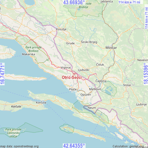
Otrić-Seoci GPS coordinates[2]
43° 9' 30.996" North, 17° 27' 2.988" East
| Map corner | latitude | longitude |
|---|---|---|
| Upper-left | 43.66936°, | 16.74771° |
| Center: | 43.15861°, | 17.45083° |
| Lower-right: | 42.64355°, | 18.15396° |
| Map W x H: | 114.1×114.1 km | = 70.9×70.9mi |
| max Lat: | 46.52694° ⇑96% North |
| Otrić-Seoci: | 43.15861° |
| min Lat: | ⇓4% South 42.54972° |
| min Long | Otrić-Seoci | max Long |
| 13.52389° | 17.45083° | 19.37694° |
| W 75.4%⇐ | ⇒24.6% E |
Elevation
Elevation of Otrić-Seoci is 29 m = 95 ft, and this is 124.3 m = 408 ft below average elevation for this country.
| Max E: |
827 m = 2713 ft | 88.6% |
| Avg. | 153.3 m = 503 ft | |
| Otrić-Seoci | 29 m = 95 ft | |
Min E: |
-1 m = -3 ft | 11.4% |
See also: Croatia elevation on elevation.city.
Geographical zone
Otrić-Seoci is located in North temperate zone (between Tropic of Cancer and the Arctic Circle). Distance of this Northern Tropic circle is 2192.9 km =1362.6 mi to South.| Distance of | km | miles | from Otrić-Seoci |
|---|---|---|---|
| North Pole | 5208.3 | 3236.3 | to North |
| Arctic Circle | 2602.4 | 1617.1 | to North |
| Tropic Cancer | 2192.9 | 1362.6 | to South |
| Equator | 4798.8 | 2981.8 | to South |


Nearby cities:
15 places around Otrić-Seoci: (largest is in red/bold)
• Gradac
10.6 km =6.6 mi,  236°
236°
• Janjina
26 km =16.2 mi,  184°
184°
• Komin
14.8 km =9.2 mi,  151°
151°
• Kraj
14.2 km =8.8 mi,  262°
262°
• Krvavac
18.6 km =11.6 mi,  144°
144°
• Kula Norinska
18.9 km =11.7 mi, 138°
• Metković
19.8 km =12.3 mi,  125°
125°
• Opuzen
18.5 km =11.5 mi, 149°
• Ploče
11.5 km =7.1 mi,  187°
187°
• Rogotin
12.4 km =7.7 mi,  169°
169°
• Staševica
3 km =1.9 mi,  223°
223°
• Sućuraj
21.8 km =13.5 mi, 260°
• Trpanj
22 km =13.7 mi, 220°
• Vlaka
18.7 km =11.6 mi,  161°
161°
• Vrgorac
8.3 km =5.2 mi,  309°
309°
Sources, notices
• [Note1] Compared only with cities in Croatia existing in our database
• [Src1] Map data: © OpenStreetMap contributors (CC-BY-SA)
• [Src2] Other city data from geonames.org with taken over terms of usage.
• [Src3] Geographical zone / Annual Mean Temperature by Robert A. Rohde @ Wikipedia
