Poreč geodata
Poreč (Istria) is a seat of a second-order administrative division; located in Croatia in Europe/Zagreb (GMT+2) time zone. With population of 10,499 people, there are 41 cities with bigger population in this country. Compared to other cities in Croatia, 64.9% of cities are located further ↑North; 99.8% of cities are located further →East and 98.2% of cities have higher elevation than Poreč. Note1


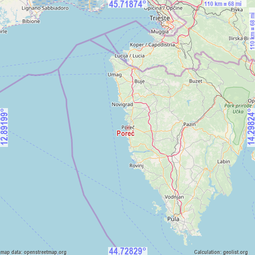
Poreč GPS coordinates[2]
45° 13' 32.412" North, 13° 35' 42.396" East
| Map corner | latitude | longitude |
|---|---|---|
| Upper-left | 45.71874°, | 12.89199° |
| Center: | 45.22567°, | 13.59511° |
| Lower-right: | 44.72829°, | 14.29824° |
| Map W x H: | 110.1×110.1 km | = 68.4×68.4mi |
| max Lat: | 46.52694° ⇑64.9% North |
| Poreč: | 45.22567° |
| min Lat: | ⇓35.1% South 42.54972° |
| min Long | Poreč | max Long |
| 13.52389° | 13.59511° | 19.37694° |
| W 0.2%⇐ | ⇒99.8% E |
Elevation
Elevation of Poreč is 4 m = 13 ft, and this is 149.3 m = 490 ft below average elevation for this country.
| Max E: |
827 m = 2713 ft | 98.2% |
| Avg. | 153.3 m = 503 ft | |
| Poreč | 4 m = 13 ft | |
Min E: |
-1 m = -3 ft | 1.8% |
See also: Croatia elevation on elevation.city.
Geographical zone
Poreč is located in North temperate zone (between Tropic of Cancer and the Arctic Circle). Distance of this North polar circle is 2372.6 km =1474.3 mi to North.| Distance of | km | miles | from Poreč |
|---|---|---|---|
| North Pole | 4978.4 | 3093.4 | to North |
| Arctic Circle | 2372.6 | 1474.3 | to North |
| Tropic Cancer | 2422.7 | 1505.4 | to South |
| Equator | 5028.6 | 3124.6 | to South |


Nearby cities:
15 places around Poreč: (largest is in red/bold)
• Brtonigla
17.5 km =10.9 mi,  8°
8°
• Funtana
5.7 km =3.5 mi,  172°
172°
• Grožnjan
19.8 km =12.3 mi,  30°
30°
• Karojba
19.7 km =12.2 mi,  64°
64°
• Kaštelir
11.2 km =7 mi,  39°
39°
• Novigrad
10.3 km =6.4 mi,  343°
343°
• Rovinj
16.6 km =10.3 mi, 167°
• Sveti Lovreč Pazenatički
12.8 km =8 mi,  115°
115°
• Tar
8.7 km =5.4 mi,  15°
15°
• Tinjan
19.2 km =11.9 mi,  92°
92°
• Visignano
11.3 km =7 mi, 60°
• Vižinada
17.2 km =10.7 mi,  47°
47°
• Vrsar
8.5 km =5.3 mi, 174°
• Vrvari
3.1 km =1.9 mi, 92°
• Červar-Porat
5.1 km =3.2 mi,  1°
1°
Sources, notices
• [Note1] Compared only with cities in Croatia existing in our database
• [Src1] Map data: © OpenStreetMap contributors (CC-BY-SA)
• [Src2] Other city data from geonames.org with taken over terms of usage.
• [Src3] Geographical zone / Annual Mean Temperature by Robert A. Rohde @ Wikipedia
