Brtonigla geodata
Brtonigla (Istria) is a seat of a second-order administrative division; located in Croatia in Europe/Zagreb (GMT+2) time zone. With population of 831 people, there are 573 cities with bigger population in this country. Compared to other cities in Croatia, 52.8% of cities are located further ↑North; 99.4% of cities are located further →East and 58.9% of cities have higher elevation than Brtonigla. Note1


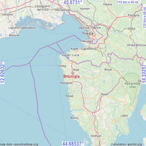
Brtonigla GPS coordinates[2]
45° 22' 53.004" North, 13° 37' 45.984" East
| Map corner | latitude | longitude |
|---|---|---|
| Upper-left | 45.8731°, | 12.92632° |
| Center: | 45.38139°, | 13.62944° |
| Lower-right: | 44.88537°, | 14.33257° |
| Map W x H: | 109.8×109.8 km | = 68.2×68.2mi |
| max Lat: | 46.52694° ⇑52.8% North |
| Brtonigla: | 45.38139° |
| min Lat: | ⇓47.2% South 42.54972° |
| min Long | Brtonigla | max Long |
| 13.52389° | 13.62944° | 19.37694° |
| W 0.6%⇐ | ⇒99.4% E |
Elevation
Elevation of Brtonigla is 111 m = 364 ft, and this is 42.3 m = 139 ft below average elevation for this country.
| Max E: |
827 m = 2713 ft | 58.9% |
| Avg. | 153.3 m = 503 ft | |
| Brtonigla | 111 m = 364 ft | |
Min E: |
-1 m = -3 ft | 41.1% |
See also: Croatia elevation on elevation.city.
Geographical zone
Brtonigla is located in North temperate zone (between Tropic of Cancer and the Arctic Circle). Distance of this North polar circle is 2355.2 km =1463.5 mi to North.| Distance of | km | miles | from Brtonigla |
|---|---|---|---|
| North Pole | 4961.1 | 3082.7 | to North |
| Arctic Circle | 2355.2 | 1463.5 | to North |
| Tropic Cancer | 2440 | 1516.1 | to South |
| Equator | 5045.9 | 3135.4 | to South |


Nearby cities:
15 places around Brtonigla: (largest is in red/bold)
• Buje
4.1 km =2.5 mi,  38°
38°
• Funtana
23.1 km =14.4 mi,  184°
184°
• Grožnjan
7.4 km =4.6 mi,  92°
92°
• Karojba
17.6 km =10.9 mi,  120°
120°
• Kaštelir
9.7 km =6 mi,  153°
153°
• Motovun
16.3 km =10.1 mi,  107°
107°
• Novigrad
9.3 km =5.8 mi,  217°
217°
• Oprtalj
15.4 km =9.6 mi, 89°
• Poreč
17.5 km =10.9 mi,  188°
188°
• Tar
9 km =5.6 mi, 182°
• Umag
9.9 km =6.2 mi,  304°
304°
• Visignano
13.7 km =8.5 mi, 148°
• Vižinada
11.6 km =7.2 mi, 119°
• Vrvari
17.5 km =10.9 mi, 178°
• Červar-Porat
12.4 km =7.7 mi, 191°
Sources, notices
• [Note1] Compared only with cities in Croatia existing in our database
• [Src1] Map data: © OpenStreetMap contributors (CC-BY-SA)
• [Src2] Other city data from geonames.org with taken over terms of usage.
• [Src3] Geographical zone / Annual Mean Temperature by Robert A. Rohde @ Wikipedia
