Oriovac geodata
Oriovac (Slavonski Brod-Posavina) is a seat of a second-order administrative division; located in Croatia in Europe/Zagreb (GMT+2) time zone. With population of 2,031 people, there are 206 cities with bigger population in this country. Compared to other cities in Croatia, 69.8% of cities are located further ↑North; 79.1% of cities are located further ←West and 53.4% of cities have higher elevation than Oriovac. Note1


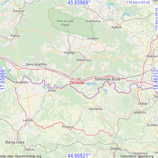
Oriovac GPS coordinates[2]
45° 9' 57.996" North, 17° 45' 36" East
| Map corner | latitude | longitude |
|---|---|---|
| Upper-left | 45.65969°, | 17.05688° |
| Center: | 45.16611°, | 17.76° |
| Lower-right: | 44.66821°, | 18.46313° |
| Map W x H: | 110.2×110.2 km | = 68.5×68.5mi |
| max Lat: | 46.52694° ⇑69.8% North |
| Oriovac: | 45.16611° |
| min Lat: | ⇓30.2% South 42.54972° |
| min Long | Oriovac | max Long |
| 13.52389° | 17.76° | 19.37694° |
| W 79.1%⇐ | ⇒20.9% E |
Elevation
Elevation of Oriovac is 120 m = 394 ft, and this is 33.3 m = 109 ft below average elevation for this country.
| Max E: |
827 m = 2713 ft | 53.4% |
| Avg. | 153.3 m = 503 ft | |
| Oriovac | 120 m = 394 ft | |
Min E: |
-1 m = -3 ft | 46.6% |
See also: Croatia elevation on elevation.city.
Geographical zone
Oriovac is located in North temperate zone (between Tropic of Cancer and the Arctic Circle). Distance of this North polar circle is 2379.2 km =1478.4 mi to North.| Distance of | km | miles | from Oriovac |
|---|---|---|---|
| North Pole | 4985.1 | 3097.6 | to North |
| Arctic Circle | 2379.2 | 1478.4 | to North |
| Tropic Cancer | 2416.1 | 1501.3 | to South |
| Equator | 5022 | 3120.5 | to South |


Nearby cities:
15 places around Oriovac: (largest is in red/bold)
• Bartolovci
13.5 km =8.4 mi,  82°
82°
• Batrina
7.8 km =4.8 mi,  289°
289°
• Bebrina
9.5 km =5.9 mi,  142°
142°
• Brodski Stupnik
3.4 km =2.1 mi,  86°
86°
• Gradac
16.9 km =10.5 mi,  14°
14°
• Gromačnik
15.6 km =9.7 mi, 84°
• Kaniža
11.8 km =7.3 mi,  123°
123°
• Lužani
4.2 km =2.6 mi,  272°
272°
• Nova Kapela
10.1 km =6.3 mi, 291°
• Pleternica
14.1 km =8.8 mi, 14°
• Sibinj
11.9 km =7.4 mi, 76°
• Slobodnica
13.6 km =8.5 mi, 91°
• Sulkovci
11.4 km =7.1 mi, 6°
• Vrbova
15.4 km =9.6 mi, 292°
• Šumeće
13.6 km =8.5 mi, 137°
Sources, notices
• [Note1] Compared only with cities in Croatia existing in our database
• [Src1] Map data: © OpenStreetMap contributors (CC-BY-SA)
• [Src2] Other city data from geonames.org with taken over terms of usage.
• [Src3] Geographical zone / Annual Mean Temperature by Robert A. Rohde @ Wikipedia
