Sibinj geodata
Sibinj (Slavonski Brod-Posavina) is a seat of a second-order administrative division; located in Croatia in Europe/Zagreb (GMT+2) time zone. With population of 2,736 people, there are 157 cities with bigger population in this country. Compared to other cities in Croatia, 67.2% of cities are located further ↑North; 80.8% of cities are located further ←West and 51.7% of cities have higher elevation than Sibinj. Note1


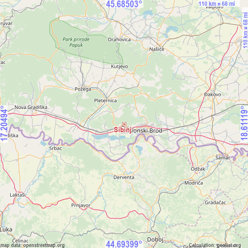
Sibinj GPS coordinates[2]
45° 11' 30.012" North, 17° 54' 29.016" East
| Map corner | latitude | longitude |
|---|---|---|
| Upper-left | 45.68503°, | 17.20494° |
| Center: | 45.19167°, | 17.90806° |
| Lower-right: | 44.69399°, | 18.61119° |
| Map W x H: | 110.2×110.2 km | = 68.5×68.5mi |
| max Lat: | 46.52694° ⇑67.2% North |
| Sibinj: | 45.19167° |
| min Lat: | ⇓32.8% South 42.54972° |
| min Long | Sibinj | max Long |
| 13.52389° | 17.90806° | 19.37694° |
| W 80.8%⇐ | ⇒19.2% E |
Elevation
Elevation of Sibinj is 124 m = 407 ft, and this is 29.3 m = 96 ft below average elevation for this country.
| Max E: |
827 m = 2713 ft | 51.7% |
| Avg. | 153.3 m = 503 ft | |
| Sibinj | 124 m = 407 ft | |
Min E: |
-1 m = -3 ft | 48.3% |
See also: Croatia elevation on elevation.city.
Geographical zone
Sibinj is located in North temperate zone (between Tropic of Cancer and the Arctic Circle). Distance of this North polar circle is 2376.3 km =1476.6 mi to North.| Distance of | km | miles | from Sibinj |
|---|---|---|---|
| North Pole | 4982.2 | 3095.8 | to North |
| Arctic Circle | 2376.3 | 1476.6 | to North |
| Tropic Cancer | 2418.9 | 1503 | to South |
| Equator | 5024.8 | 3122.3 | to South |


Nearby cities:
15 places around Sibinj: (largest is in red/bold)
• Bartolovci
2 km =1.2 mi,  118°
118°
• Bebrina
11.9 km =7.4 mi,  209°
209°
• Brodski Stupnik
8.6 km =5.3 mi,  252°
252°
• Brodski Varoš
5.7 km =3.5 mi,  101°
101°
• Bukovlje
12.7 km =7.9 mi,  93°
93°
• Gornja Vrba
13 km =8.1 mi,  108°
108°
• Gromačnik
4.1 km =2.5 mi, 109°
• Kaniža
9.5 km =5.9 mi,  190°
190°
• Oriovac
11.9 km =7.4 mi,  256°
256°
• Podcrkavlje
8.8 km =5.5 mi,  65°
65°
• Podvinje
9.3 km =5.8 mi, 90°
• Slavonski Brod
9.1 km =5.7 mi, 112°
• Slobodnica
3.8 km =2.4 mi,  149°
149°
• Sulkovci
13.3 km =8.3 mi,  309°
309°
• Šumeće
13.1 km =8.1 mi, 190°
Sources, notices
• [Note1] Compared only with cities in Croatia existing in our database
• [Src1] Map data: © OpenStreetMap contributors (CC-BY-SA)
• [Src2] Other city data from geonames.org with taken over terms of usage.
• [Src3] Geographical zone / Annual Mean Temperature by Robert A. Rohde @ Wikipedia
