Obrovac geodata
Obrovac (Zadarska) is a seat of a second-order administrative division; located in Croatia in Europe/Zagreb (GMT+2) time zone. With population of 1,060 people, there are 428 cities with bigger population in this country. Compared to other cities in Croatia, 81% of cities are located further ↑North; 79.7% of cities are located further →East and 93.3% of cities have higher elevation than Obrovac. Note1


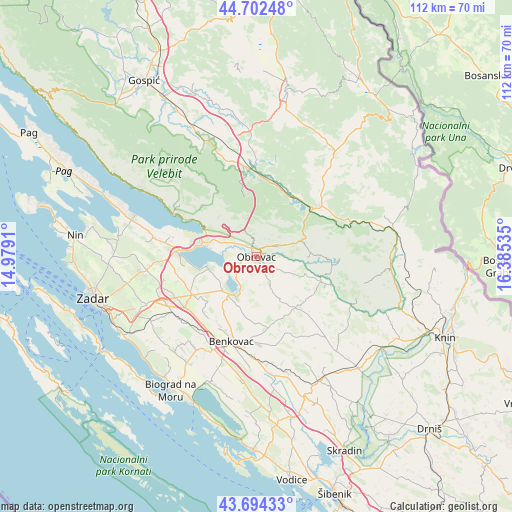
Obrovac GPS coordinates[2]
44° 12' 2.016" North, 15° 40' 55.992" East
| Map corner | latitude | longitude |
|---|---|---|
| Upper-left | 44.70248°, | 14.9791° |
| Center: | 44.20056°, | 15.68222° |
| Lower-right: | 43.69433°, | 16.38535° |
| Map W x H: | 112.1×112.1 km | = 69.7×69.7mi |
| max Lat: | 46.52694° ⇑81% North |
| Obrovac: | 44.20056° |
| min Lat: | ⇓19% South 42.54972° |
| min Long | Obrovac | max Long |
| 13.52389° | 15.68222° | 19.37694° |
| W 20.3%⇐ | ⇒79.7% E |
Elevation
Elevation of Obrovac is 13 m = 43 ft, and this is 140.3 m = 460 ft below average elevation for this country.
| Max E: |
827 m = 2713 ft | 93.3% |
| Avg. | 153.3 m = 503 ft | |
| Obrovac | 13 m = 43 ft | |
Min E: |
-1 m = -3 ft | 6.7% |
See also: Croatia elevation on elevation.city.
Geographical zone
Obrovac is located in North temperate zone (between Tropic of Cancer and the Arctic Circle). Distance of this Northern Tropic circle is 2308.7 km =1434.6 mi to South.| Distance of | km | miles | from Obrovac |
|---|---|---|---|
| North Pole | 5092.4 | 3164.3 | to North |
| Arctic Circle | 2486.5 | 1545 | to North |
| Tropic Cancer | 2308.7 | 1434.6 | to South |
| Equator | 4914.6 | 3053.8 | to South |


Nearby cities:
15 places around Obrovac: (largest is in red/bold)
• Benkovac
19.3 km =12 mi,  196°
196°
• Buković
19 km =11.8 mi,  191°
191°
• Gornji Karin
8.1 km =5 mi,  208°
208°
• Gračac
17.1 km =10.6 mi,  50°
50°
• Jesenice
9 km =5.6 mi,  291°
291°
• Kruševo
3.2 km =2 mi,  233°
233°
• Lovinac
21.2 km =13.2 mi,  0°
0°
• Novigrad
10.4 km =6.5 mi,  259°
259°
• Podgradina
15.6 km =9.7 mi, 263°
• Posedarje
16.4 km =10.2 mi,  275°
275°
• Pridraga
10 km =6.2 mi,  247°
247°
• Slivnica
19.2 km =11.9 mi, 284°
• Starigrad
22.1 km =13.7 mi,  298°
298°
• Suhovare
22.4 km =13.9 mi, 257°
• Škabrnje
21.9 km =13.6 mi,  236°
236°
Sources, notices
• [Note1] Compared only with cities in Croatia existing in our database
• [Src1] Map data: © OpenStreetMap contributors (CC-BY-SA)
• [Src2] Other city data from geonames.org with taken over terms of usage.
• [Src3] Geographical zone / Annual Mean Temperature by Robert A. Rohde @ Wikipedia
